Showing posts with label Natural Bridge. Show all posts

Saturday, October 2, 2021

Rogue Gorge Loop


"A fallen leaf is nothing more than a summer's wave good-bye" - Unknown

A wall of yellow leaves

If that's true then then this last hike was a thundering round of applause from an appreciative crowd stomping their feet, shouting "Encore! Encore!" at the top of their lungs, hoisting in tribute thousands of lit cigarette lighters that twinkled in the dark auditorium like so many stars against a night sky on a summer campout. I may be dating myself because I don't think they light lighters at the end of concerts anymore, it's probably cell phones nowadays. But at any rate, the autumn's concert was a wonder to behold on the Upper Rogue River Trail.

The trail was oft multi-colored

And speaking of art and artists, I was Supreme Commander of this hike today. Actually Edwin was supposed to lead the charge on this Friends of the Umpqua venture but an injured foot (he'll be ok) put paid to that idea. Additionally, the Jack Fire had overrun the South Umpqua River Road, rendering his hike inaccessible anyway. All that left me free to choose where and how and maybe even why we were going. Since I so enjoyed the autumnal aspects of my last hike at Suttle Lake and was left wanting more of the colored same, it was time for yet another reprise of the Rogue Gorge loop, arguably the best autumn hike in all of southern Oregon.

It's autumn time along the Rogue River

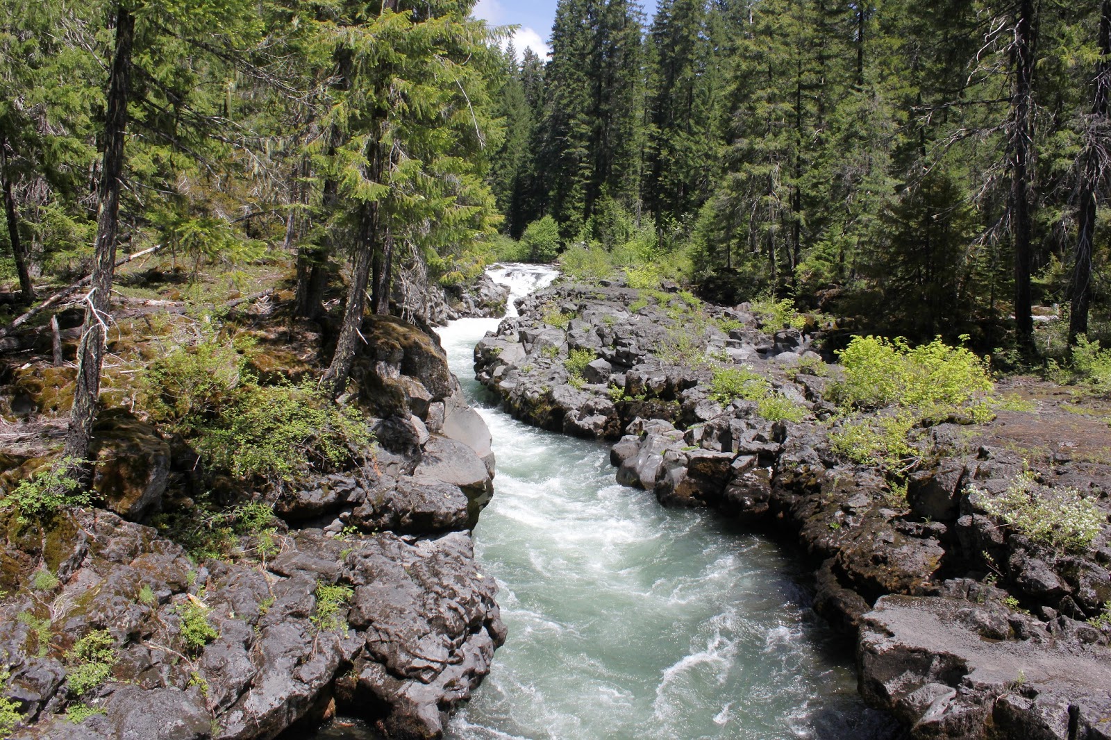
Setting out from the Rogue Gorge Viewpoint, our first little item of interest was the Rogue Gorge itself. The gorge used to be a lava tube but became a gorge when the roof caved in. Whether tube or gorge, the mighty Rogue was not at all happy about being squeezed into the tube, and makes its opinion known in a frothing and roaring diatribe from the bottom of the narrow defile. But tell it to the rock, because rock don't care, and the immovable lava walls do what they have done for epochs, which is to guide the river out of the gorge and into a more benign canyon.

Figurative forest fire!
Someone, call figurative 9-1-1!

Almost immediately after hiking away from the gorge, this hike became mostly all about the fall colors. We were on the shady side of the river so the vegetation was still primarily green in color, but there were plenty of reds and yellows scattered throughout to hint at the upcoming show. But on the other side of the river, where it was sunny and bright, the vine maple leaves had already burst into bright reds that had us putting on sunglasses so as to prevent further retinal damage. 

Autumn reflects on the Rogue

Once the trail made a pronounced turn to the south, we hiked in bright colors for the remainder of the hike. Each vine maple tree was an explosion of color and light next to the river. The Rogue was running slow and ponderous while small whirlpools and eddies made for interesting textures on the surface. The bright colors reflected poetically and it seemed like a whole blurry and colorful world lay just beneath the river’s surface.

A small cascade on an angry river

Most of my charges had not been here before so I communicated that when the trail reached the bridge crossing the river, we were all to stop and regather. Naturally, Lane stopped at the first bridge he saw which happened to be at Union Creek so we regathered twice. No harm, no foul though, and after a quick bridgeside confab at the correct bridge, we all decided to cross the river and follow the Upper Rogue River Trail, if only for the reason I told everybody that's what we were doing.

The forest near Natural Bridge was simply sublime

The river at the bridge seethed and roiled as it was confined in yet another narrow gorge but we traded in all that sound and fury for woods peaceful and quiet, excepting the huffing and puffing sounds of hikers attacking the only uphill section of trail on this hike. The woods were eminently beautiful with colors slightly muted as this side of the hill was fairly well shaded.

The Rogue, as it approaches Natural Bridge

Once we hiked up and over that lushly wooded ridge, it was back to a level hike next to the river as we approached Natural Bridge. Natural Bridge was formed when the roof of lava tube that swallowed the Rogue in its entirety collapsed, except for one 25 yard section. As the river pours into all that remains of the lava tube, the visual effect is that the Rogue River mysteriously disappears from sight only to emerge a short distance later in a geologic game of hide-and-seek. For some reason, you never see kayakers here, probably something to do with that brief underground journey.

Why we hike

After a nice little lunch 'n laze next to a busy parking lot, we returned by way of the Rogue Gorge Trail. The afternoon sun shone brightly on an amazingly colorful trail and my inner photographer ran amok. So many leaves and so many colors and so many reflections on the river. Despite the bright sun ostensibly baking the trail, the temperature was mild so sun stroke was not an option today. The day was perfect, as was this hike.

Local color

So, just like my walk at Suttle Lake, I really enjoyed the whole autumn color thing and was left wanting more. They say that too much of a good thing is a bad thing but I disagree, I could do this again and again and again and....

Every leaf a work of art unto itself

For more photos of this hike, please visit the Flickr album.

Friday, October 16, 2020

Rogue Gorge - Upper Rogue River Trail Loop


The genesis of this hike began when younger brother Don prostrated himself at my feet, begging "O wise and wonderful Older Brother, I am but a mere gnat caught in the glittering web of your awesomeness, Please o please, can you take me on one of your hikes and render me worthy as I bask in the golden glow of your presence?" Now, if you run into Don out on the street somewhere and question him as to the veracity of my account, he may vehemently deny that such a conversation ever took place. But, my rejoinder is that my blog is part of the Internet and if it's on the Internet, then it must be true.

Just a beautiful day for a hike!

The Cascade Mountain Range in Oregon are a chain of tall peaks covered with countless acres of tall conifers. Being evergreens, the conifers tend to ignore that autumn foo-foo stuff of bright colors and all that nonsense. What's wrong with being tall and dark green, anyway? Nothing, but autumn can be so much fun when leaves of trees so inclined celebrate winter's impending arrival with a burst of leafy color. So what's a hiker to do in order to enjoy the autumn plumage? Why, you must go where the vine maples grow, and that's how younger brother Don and I found ourselves on the Rogue Gorge Trail once the proper amount of groveling had taken place.

The Rogue River churns in its namesake gorge

Don had never been to the Upper Rogue River so I was able to hike vicariously, seeing the hike anew through his eyes. Our hike began at the Rogue Gorge which is a geologic marvel in its own right. Here, the Rogue River flows through an ancient lava tube whose roof had collapsed millenia ago. The river is all white water as it angrily seethes at the bottom of the narrow gorge and the view thereof was a great way to begin the day's venture.

The river reflects

After gawking at the gorge, we set foot on the Rogue Gorge Trail which follows the river to touristy Natural Bridge. It didn't take long for this to become the quintessential autumn hike. The riverbanks were bathed in warm sunlight and the vine maples were in bright orange, red, and yellow form. Dogwood likewise went colorful but tended more toward a pinkish hue. The river was tranquil and serene here and the surrounding colorful foliage and trees painted watercolor reflections on the river's surface.

Colorful leaves were one of the stories of this hike

The next few miles were mostly a level walk underneath either a deep blue sky or vine maple leaves illuminated by the bright sun like so many millions of colored lights. Don also had a camera so he wasn't any more annoyed than usual with his wiser and more handsome big brother when much mutual photography ensued. 

Much photography ensued

The basic calm tenor of the river changed when the river used the readily available slot of yet another collapsed lave tube to funnel into, raging and frothing with angry white water as it did so. A picturesque footbridge crosses the river here and the bridge makes a convenient place to stop and take photographs of the scenic river constrained by unyielding black and gray lava.

The river divides around a large boulder

More geological and/or riverine delights awaited us at Natural Bridge after another mile and a half of riverside walking. Natural Bridge is where a lava tube did not collapse and the Rogue River enters the tube and disappears completely from sight like a child playing hide-and-seek, only to emerge about 75 yards downstream, ready to resume its long above-ground journey to the Pacific Ocean. Don was suitably impressed, gushing "Gee whillikers Totally Awesome Big Brother, this is amazing!" while I, as a jaded and faded Upper Rogue River veteran, stifled a yawn and replied. "What, that old thing?"

Just follow the Yellow Leaf Road!

Actually, the bridge part of Natural Bridge was the least visually interesting thing at this popular tourist spot. More fun was the river thundering in its narrow defile in a series of thundering cascades and roaring falls. Much photography (times two) ensued. And from there, we decided to return via the Upper Rogue River Trail for variety's sake.

Vine maple, putting on its usual autumn show

The Upper Rogue River Trail was initially a pleasantly level stroll along a fairly well-behaved river among some old-growth tree giants. Don stopped to gawk at a couple of them in suitably awestruck fashion. Nowhere near as tall, vine maples thrived in happy profusion and because they were on the mostly sunny side of the river, their leaves were as flamboyantly colorful as a Carnaval parade float in Río. 

Kindred spirit in Don, at least when it comes to photography

The return on the opposite side of the river did provide the only uphill stretch of this hike and my legs complained while Don and his much younger legs had no trouble at all. Continually beseeching him to wait for me, I may have even groveled a bit myself on the uphill slog. Once we crossed back over the river, the remainder of the walk was pleasantly level next to a soothingly calm and placid river as we hiked in easy brotherly companionship, if only for the reason Don had not yet read what I said about him in my blog. 

Watercolor painting

For more photos of this hike, please visit the Flickr album.

Wednesday, April 15, 2020

Knob Falls

Talk about sending mixed signals! Right there on their Facebook page, the Umpqua National Forest clarified their position on the pandemic related trail closures, clearly stating that the trails are open, you can hike on them, it's just the trailhead parking lots that are off limits. Sounded good to me, so I drove up the North Umpqua Highway in search of a secluded trailhead on the North Umpqua Trail. However, the reality on the ground was that every trail had crowd control tape stretched across it with signs stating in no uncertain terms that this area was closed. WTF?

No habrá caminata hoy!
Well, what's a confused and uncertain hiker to do? I had talked to the Rogue River - Siskiyou National Forest office when the pandemic closure order first came about and was told it was OK to hike on the trails but they had closed and gated all the trailheads. In fact, I was advised just to park my vehicle on the road, hop over the gate, and walk to the trailhead. Since that particular office was so clear over the phone, I just continued driving up the North Umpqua Highway to the Upper Rogue River area and found the developed sites closed but trails open, no mixed signals at all.

Every hike should start like this
I parked the car at Woodruff Bridge, exchanged socially distant waves with a fisherman standing on the rocky banks, and commenced hiking. When I last hiked a couple of weeks ago at the North Bank, spring had been well under way but not so much here. This area had just, and only just, freed itself from winter's wintry embrace and there still was a noticeable chill on this on again, off again sunny or cloudy day, depending on the weather mood of the moment. Small patches of snow lay across the trail in shady places but were only an inch or so thick, so trail navigation was never at issue.

Flies squabble over a trillium


I've previously hiked here in spring and the lush greenery was amazing. However, being just this closely removed from winter, the vine maple, alder, and dogwood trees had not yet leafed out, although all sported leaf and flower buds except for the alder, which sends out dangling blossoms well ahead of its leaves. On the forest floor, trillium was just starting to bloom in a harbinger of that rampant spring greenery I just mentioned earlier.

Rock garden, Rogue River style
The upper Rogue River was a constant companion on this hike as the trail followed the river banks which in many cases, was comprised of hardened lava flows. Where the river was beachy, the sand was not true sand at all but volcanic ash, a legacy inherited from a Mount Mazama eruption an epoch or two ago. At any rate, the river immediately upstream of Woodruff Bridge was a noisy place as it roared, whether diving into rocky chutes or tumbling over a series of stair-step cascades. Small social trails braided off the main trail to service the photography crowd, and I partook thereof on many occasions.

What the world looks like without my glasses
At about the mile mark, the river calmed down where it flowed in languid pools with mirrorlike surfaces. Reflections were a thing and I partook some more of those social trails to admire the various impressionistic artwork of upside-down forests and trees painted upon the river.

Trail through a sparsely vegetated forest
After the calm river portion of this hike, the trail peeled away from the river a bit and headed uphill through a forest that was "going commando", seeing how it was clad with plenty of trees but little or no undergrowth. The reward for the uphill hiking was a rickety trail heading downhill on a narrow ridge for a front row seat of all the action at Knob Falls.

Knob Falls from my rocky perch


Knob Falls isn't very easy to see in its entirety but the sub-woofer basso profundo, whose basso and profundo reverberated through the forest like the bass solo reverberating through an adoring crowd at an AC/DC concert, advertised the presence of the thundering cascade tucked into a narrow chasm. The path lets you get as close as you dare to the falls and I did not dare as much as I could, because a misstep here would be fatal as the falls would chew you up into little pieces.

The river takes the Knob Falls plunge
Knob Falls is not one cascade, per se, but a series of booming cascades tumbling from pool to pool, The river has only one color and that is white as the driven snow, which makes sense, because the high volume of water this time of year is a direct result of snow melt in the higher elevations. After a lengthy but appreciative contemplation of the unbridled power and rage of a river seething in a slot canyon, I picked my way up the rickety path and continued my hike on the Upper Rogue River Trail.

Some of that Upper Rogue scenery
Fallen trees began to appear on the trail with ever increasing frequency and while tedious and annoying, getting around the trees remained doable. At this point, the trail was unwilling to give up its hard won elevation gain, so the path would stay up high above the river. On the opposite side of the river was an imposing cliff with a lava dike extruding from the middle of it, and the river tumbled noisily over the rocks deposited there over the ages. Here, it was hard to imagine the the river ever pacifying itself long enough to allow for artistic reflections on the surface.

Thundering waters at Natural Bridge
The scenic area at Natural Bridge was one of those developed sites that had been gated shut at the highway and it was eerie to have the entire place to myself, something that never happens at this popular place always overrun with tourists. At least I didn't have to jostle anybody to get a camera-worthy spot along the fence railings keeping said tourists out of the angry river. 

The Rogue pours over a cascade
The actual bridge of Natural Bridge is a lava tube where the Rogue River disappears from sight when it flows through the underground conduit. When the river is running full, like on this day, the bridge is underwater and not at all visible. To be honest, I prefer the river in its raging glory instead of seeing the river disappear completely from sight. I was rewarded today as the river thundered through a narrow channel created when a lava tube collapsed. Natural Bridge made for a logical turnaround point, so it was back the way I had come after an appreciative lollygag at the combination of geologic and hydrologic wonders.

Mixed signals of a different sort


When I got home, I sent a message to the Forest Service, asking for clarification about the trail closures noted on the North Umpqua Trail. They did respond with apologies, stating that the trails had been closed in error and they would be removing the barriers within the next few days. Glad to have those mixed signals get unmixed!


Peace like a river
For more photos of this socially distant hike, please visit the Flickr album.


Saturday, May 25, 2013

Natural Bridge (Upper Rogue River Trail)

The weather gods have a capricious sense of humor. First, they foisted a warm and dry May upon us; being experienced and knowing how things work, I resisted the enticement and kept my hikes low in elevation or on the coast. But, after my Grizzly Peak hike, I decided to go with the warm and dry flow and scheduled a hike into the Rogue-Umpqua Divide Wilderness. So, the weather that day was 21 degrees, 100% chance of snow, and 30 m.p.h. winds; needless to say the hike was canceled. On the subsequent weekend with the weather forecast calling for clouds and 40% chance of rain, we naturally enjoyed cloudless sunshine all day. Sometimes the weather gods's capriciousness can work in our favor, too.

The Rogue, on tranquilizers
This was a Friends of the Umpqua venture led by yours truly and there was only one brief uphill section and we didn't have to ford the river, most unusual for a Richard Hike. I must be losing my touch! At any rate, 19 Friends piled out of their cars at Woodruff Bridge. Normally, we head south on the Upper Rogue River Trail to Takelma Gorge but not today, we were off instead to see Knob Falls and Natural Bridge, both to the north of Woodruff Bridge.


I repeat:  SPRING IS FINALLY HERE!


Within the first several yards of trail we encountered spring flowers, the rushing Rogue River, blue sky above, and a green trail that tunneled through the newly leafed out vine maples. In other words:  SPRING IS FINALLY HERE! I don't think I hiked as much as I capered down the trail, kicking my heels like a new born lamb. Except lambs have considerably more hair than me, I probably more resemble a one-day old buzzard chick asking for regurgitated dead meat...no wonder buzzard chicks don't kick up their heels.  

Let the falls begin!
The Rogue River initially was on its best behavior, lazily coursing in tranquil and serene pools that reflected the green forest. Of course, that would change and a short uphill push took us to an overlook of Knob Falls where the Rogue became considerably rowdier. Basically more cascade than an actual waterfall, the Rogue seethes in a confined slot canyon as it tumbles 60 feet or so. A side trail drops hikers down a narrow ridge to a closer view of the action.

Note to self: Do not camp at a bottom of a cliff
Attaining the high ground overlooking the river, the path stayed high above the river. The trail was shady and pleasant but did provide occasional views to the river, now constrained to a narrow canyon with a massive lava cliff on the other side. Large rocks were in the river, delivered courtesy of the crumbling cliff.  

False Solomon seal
As mentioned before, spring was happening on the Upper Rogue and cameraholics spent a lot of time prone upon the trail, taking pictures of Oregon grape (all hail our state flower!), wild iris (my World of Warcraft user ID), creeping ceanothus (my Halloween costume), and the exotic looking calypso orchid (my stage name).  Pink and white spears of candystick were pushing up through the forest duff.  But really, this hike was all about the dogwood and vine maples.

Woof woof...it's a dogwood flower
Dogwood was blooming everywhere and I had ample opportunity to practice the craft of taking pictures of dogwood flowers against the blue sky.  The vine maples were leafing out and the very air seemed green underneath their leafy bowers draped over the trail.  As an aside, does anyone ever use the word "bower" besides long-dead poets and hiking bloggers? Anyway, it was definitely a green and white hike.


Quick, Rogue River, to the Bat Cave!
At about 3.5 miles our rugged little trail became paved. Paved? There's no paved in hiking! We had arrived at Natural Bridge, a popular (and paved) tourist spot on the Rogue. The bridge refers to a lava tube into which the entire Rogue River disappears only to surface a short ways further down the canyon. However, in spring when the river is full, the bridge is hidden beneath the river's flow. The whitewater is pretty impressive and entertaining nonetheless and is still worth a springtime visit.


Green trail
We continued on, leaving the hordes and the railed (Rails? There's no rails in hiking!) trails behind, returning to a bona fide dirt and rock path through rampant greenery.  After a lengthy lunch on a slab of bedrock next to the river rushing around an island, we continued onto the only uphill section on this hike.

Hi ho, hi ho, across the bridge we go
Climbing up a forested ridge and then descending back down, we renewed our acquaintance with the river. Here the river runs through a collapsed lava tube and is not very happy about that. However, the seething and roiling river was extremely scenic and we enjoyed several gawk-stops along the way before crossing the river on a footbridge.


Beautiful day in the Cascade Mountains

Now all we had to was walk the 5 miles back to the car alongside the river, flowers, and trees as the sunlight slanted in the late afternoon.  So, the weather report called for showers the next day too and and I anticipated piling into the car to enjoy another sun-soaked hike.  Turned out the showers that didn't shower on this hike were saved up for the next day as it just poured rain non-stop and once again, a hike was canceled.  Darn fickle weather gods!

Candystick
For more pictures of this hike, please visit the Flickr album.