Showing posts with label Takelma Gorge. Show all posts

Friday, April 30, 2021

Takelma Gorge


Squeeze the atoms and they get excited. And when atoms get excited, great things can happen. For instance, expanding gases within the narrow confines of a piston cylinder can move a car to a trailhead. Pinching atoms through a narrow nozzle can propel a rocket into the upper atmosphere and in the unfortunate case of Space-X, the same overly excited atoms can blow the whole thing up upon landing. Watch Cousin Fred stuff himself into his cycling shorts and you realize some excited atoms are much more useful than others. And moving on from poor Cousin Fred, force a placid river into a narrow defile and you get a seething white-watered maelstrom of riverine ire. And that leads us to today's topic about hiking along the Rogue River and Takelma Gorge, and here you were all hoping I'd spew more prose about Cousin Fred and the miracle fabric that is Spandex!

British soldiers stand at attention

You'd never know an angry river would be part of this hike, judging by the scene at the Woodruff Bridge Trailhead. Initially the river was as serene as a contemplative monk in a state of bliss. The surface was smooth and if we weren't in the shadows and if the day hadn't been cloudy, the river would have reflected the scenery back at us with all the aplomb of a master painter. So much peace and tranquility reigned in the bucolic woods, I nearly wanted to fold my legs up into the lotus position and meditate, but then I'd have to call 911 to come unfold me. Besides which, a sudden explosion of fur and hooves from a stampeding elk rudely disrupted my harmonious ponderings about peace and tranquility in the forest. The atoms in my lower intestinal tract became "elk-cited" too, like a poor man's version of a SpaceX rocket but without the subsequent explosion upon touchdown.

Newborns

I've hiked on this trail many times and always, the vine maples have been one of the main attractions apart from the river and gorge. In spring or summer, the galaxy of leaves overhead imbue the very air with a soft green glow. In autumn, forget the green because it's all brilliant orange, gold, and red when the foliage set off their annual arboreal fireworks show of autumnal color. But in late April, the vine maples just kind of look at me, yawn a disinterested "Meh!", and go back to sleep. Although a few leaves were emerging, the pleated folds somewhat resembling a Spanish fan, mostly the trees were twiggy, bare, and bereft of any leaves.

Trillium matriarch (or patriarch)

So, while the vine maples said it was still winter, the trilliums were not in agreement. A healthy population of the elegant tri-petaled flowers were profusely abloom on the forest floor. Beetles and flies were happily bathing in pollen contained within the flowers, their legs and antennae coated with fine yellow dust. The older and more mature trilliums were turning various shades of pink, maroon, or magenta. So, according to the vine maples and trillium it was neither winter nor spring but somewhere in between or both at the same time,

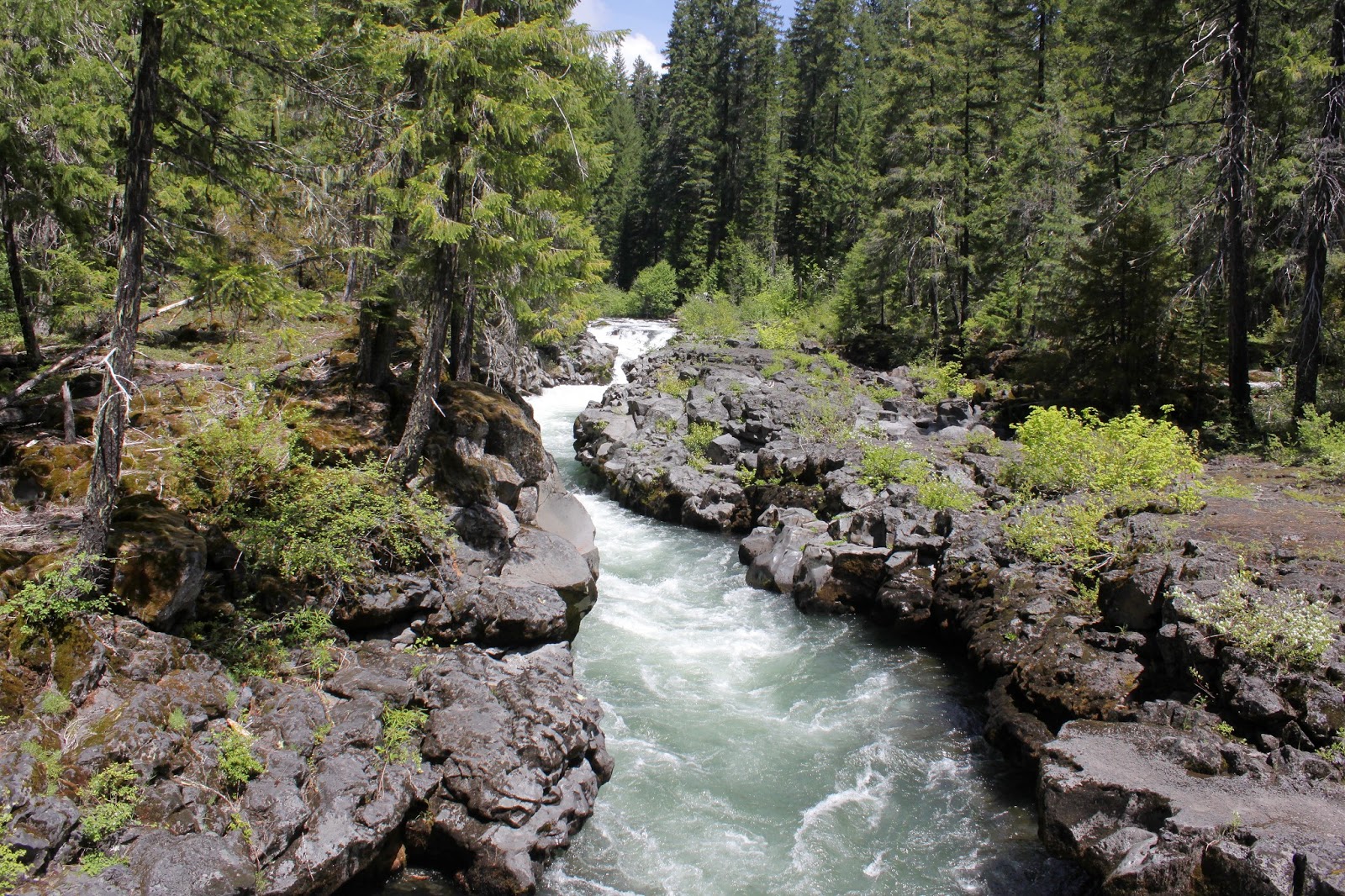
The Rogue undergoes a personality change here

After a mile or so of a relaxing hike alongside the languid river, things began to change. The river picked up speed, practicing for its upcoming gorge run. Rapids formed with increasing rapidity and the river was now making noise. I too may have been making some noise but definitely was not picking up speed. There were a number of large fallen trees spanning the river as well as several others stranded on small islands or shoals in the current, all in mute testimony that the river (just like me!) is not always as easygoing as it likes to make itself out to be.

Entrance into Takelma Gorge

Takelma Gorge was formed eons ago when lava flowed across the landscape. A river is not to be denied and after patient probing, the persistent Rogue River found a small crack in the lava and then wormed itself into the soft ashy underbelly beneath. The volcanic ash was then easily eroded until the small crack became much larger Takelma Gorge, where the differing strata of lava and ash are clearly visible on the gorge's walls. The gorge begins where the river makes a sharp turn at a rock formation I call "The Fishhook" and from a clifftop vantage point, one can stare straight down a hundred-yard length of the gorge itself.

The river eventually disappears from sight in the gorge

The trail generally stays level while the river loses elevation so the net effect is that the river drops out of sight somewhere down in the bottom of the chasm. It can still be heard though, complaining vociferously about the claustrophobic conditions in the gorge. For the next mile or so, the canyon scenery was stunning and I periodically left the trail to photograph things from the edge (but not too near the edge, I do want to see my 65th birthday, after all!). And after that display of geologic awesomeness mixed with self-righteous hydrologic fury, the Rogue River exited the gorge and returned to its natural peaceable state of enlightened contemplation.

Newly minted dogwood blossom

On the hike's return leg, my own little enlightened contemplation was rent asunder when a startled deer, no doubt surprised by my incredibly handsome arrival, burst out across the trail and got my intestinal atoms agitated all over again. While the deer disturbed my commune with the overtly calm environs of the Rogue River flowing above the gorge, the deer was still a more preferable sight than Cousin Fred and his cycling shorts.

It's all a matter of perspective

For more photos of this hike, please visit the Flickr album.


Friday, October 9, 2020

Takelma Gorge


The Archie Creek and Thielsen Fires raised all kinds of holy havoc in our Umpqua National Forest and in the aftermath, much of our favorite trail places were indefinitely closed. The combination of smoky air, burned trails, and official forest closures created chaos with the Friends of the Umpqua's hike schedule and caused some emergency changing of destinations and general all-around gnashing of teeth. 

Forest fire, arboreally speaking

However, because the planned hike on the Hot Springs Segment of the North Umpqua Trail was iffy due to post-fire forest closures, the destination was changed to Takelma Gorge. Discerning readers will note that I had recently hiked on the Hot Springs Segment, but the decision to change the destination had been made just prior to my outing there. Anyway, hike leader Coreena had never been to Takelma Gorge, so off we went for a get-acquainted hike so she could then impart that air of authority and infallibility that a hike leader should exude.

Peaceful path through an equally peaceful glade

Beginning at Woodruff Bridge Trailhead, we set out on a park-like path that tunneled through a dense jungle of vine maple. The forest was shady here and the vine maples comprise a lower level of forest underneath the surrounding tall firs. Because so much shade falls on the maples, the trail passed under a leafy arbor of light green leaves that belied the advent of early autumn. The only sign we were even in fall season was a light layer of dead leaves that swished as we strolled through them. Well, Coreena and I strolled through the leaves but the third member of our party, canine friend Gus, ran exuberantly through them as if possessed by a pack of wild demons.

Watercolor painting

While the leaves were beautiful and all that, and we never did tire of looking at them, there was a river flowing on our right to also command and demand our attention. At the beginning of the hike, the Rogue River was as placid and serene as a sleeping cat, the mirror-like surface reflecting the surrounding forest, at least until a certain dog enjoying his best day ever jumped in. Thanks to the sunlight reaching the water's edge, the vine maples on the riverbanks tended toward the bright scarlet slice on the color wheel, imparting an autumnal orange and red glow to the water's reflections.

The Rogue River enters into Takelma Gorge

After a mile or so of hiking, we saw our first rapid on the river. Then we saw another, and another, and soon they were non-stop. Clearly, the river was picking up speed as it approached the entrance of Takelma Gorge. While the river lost elevation, the trail maintained its current level so eventually the river wound up flowing well below the trail. At a geologic formation that I call "The Fishhook", the river made a sharp U-turn and entered Takelma Gorge itself. Fallen trees apparently float down the river but because of their rigid length, are unable to get around The Fishhook and simply pile up there like so many gigantic spilled toothpicks.

Takelma Gorge, in all its crack-in-the-ground glory

Takelma Gorge was formed eons ago when the river found a crack in the layer of hardened lava covering the landscape. Underneath the lava was a soft underbelly of volcanic ash and the Rogue River subsequently had no problem eroding the sandy soil underneath the rock covering. The resultant chasm that eroded over the ages is now your basic Takelma Gorge. Big chunks of the lava covering lie in the gorge, evidencing the geologic tale of how Takelma Gorge was created.

A colorful gorge, to say the least

The river seethes and roils at being so constrained in such a narrow space, it's kind of like the watery equivalent of a bottle full of Coke and Mentos (or so I have been told, not speaking from personal experience, or at least experience to which I will admit in writing).  In some places the gorge was so deep that the angry river could only be heard and not seen. The gorge is stunning and amazing, so we naturally stopped to admire the view for a bit. As we gawked, a firm grip was held on the collar of a certain compulsive and impulsive dog who feels like he needs to jump into all water he sees, even if it's churning in the bottom of a roaring chasm.

"I've fallen (in) and I can't get up!"

The gorge comes up at the halfway point of the hike and the next two miles of trail after were a mostly level walk next to a becalmed river and through some increasingly colorful woods. There was plenty of river access much to the delight of Gus who went swimming at every available opportunity. Living only in the moment, he did not plan ahead and gave us some comedic entertainment when he jumped in only to discover he had no way out because of the steep banks. "Hey food lady!" he yipped at Coreena "How about giving a poor dog a hand?"

"The happiest day of my life!"

The same awesome scenery was enjoyed all over again on the way back, the big difference being the afternoon sunlight illuminating the colorful red and orange vine maples populating the river's banks. I'm not sure if Gus enjoyed the scenery for scenery's sake, but he did spend a lot of time running through it in search of squirrel and chipmunk treasure. He probably thought the whole day was more fun than a sackful of cats let loose in the back yard. The total mileage for Coreena and I was nine-plus miles while Gus hiked about double that, all of it on a dead run. He was lights-out snoring in the back seat on the drive back, fully spent and fully sated by the day's activities.

Dogwood colors up the smoky air

For more photos of this hike, please visit the Flickr album.

Saturday, October 22, 2016

Takelma Gorge

Here in Oregon, you have to work a little bit to get a good autumn hike in. Surrounded as we are by dark evergreen forest, it's quite easy to inadvertently bypass the fall colors. It certainly had been a while for me, I checked my calendar and the last time I had what I would call a good autumn walk was back in 2012. But the secret (in Oregon, anyway) to hiking in a colory wonderland of ochre and golden goodness is to simply hike where the vine maples are, usually near a river or stream.  And if the vine maples happen to stand next to some fantastic scenery, then the hike gets booted up to a whole other level of awesome.

Gorgeous Gorge!

Take Takelma Gorge, for example. The Rogue River gets stuffed into a narrow gorge and is not particularly happy about being so constrained. The river seethes noisily in its confines like King Kong chained inside  a wooden shipping crate. However, it would be pretty awesome to stand next to the shipping crate with a raging King Kong in it and so it is with hiking on the edge of a gorge so deep, you cannot see the river roiling at the bottom Yet the gorge is also so narrow you can hurl a bowling ball left-handed across to the other side, and we get to hike just a few feet from the edge. Hiking doesn't get much better than that! However, in mid-October, as awesome as Takelma Gorge is, it almost gets upstaged by the yellow, russet, orange, and scarlet hues of the vine maples.

This is better looking than a motorcycle accident
This Friends of the Umpqua hike in Takelma Gorge got off to an inauspicious start on the drive to the Upper Rogue River. In front of us, a pair of vacationing motorcyclists ran into each other and spilled bodies, motorcycles, and motorcycle parts all over the road. Fortunately, they were wearing flack jackets and avoided serious injury. We had our doctors (lucky we had two in our party) check them out to make sure they were OK. One of the riders had an obviously broken hand but he was in denial and was going to try continuing on with his journey. Since I cycled 78 miles AFTER breaking my wrist and jaw in a cycling mishap, I totally understood. Also, from my experience, I knew at some point he'd figure out he was hurt worse than he hoped he was and would seek treatment, even if he didn't know it at the moment. At any rate, we were late getting to the trailhead and Medford hiking buddies Glenn, Carol, and Katie the Banana-Eating Dog had to wait quite a bit for us to arrive.

On the Upper Rogue River Trail


Starting at the Woodruff Bridge Trailhead,  we set out onto the Upper Rogue River Trail whose entire 48-mile length I WILL backpack someday, even though I've been saying that for years. Immediately, all thoughts of glorious gorge-ous gorges was driven from our heads by the yellow leaves surrounding the trail. The trail was carpeted with dead leaves which muffled our footfalls as we walked, imparting a reverential hush to the hike. Lane, Sharon, and I soon lagged behind with very busy cameras.

Serene and tranquil, but not for long!
The trail ambled close to the Rogue River, it's surface as smooth as a marble countertop. I was going to say "...as smooth as an incredibly handsome hiking leader" but that's a different kind of smooth! The river wasn't always that smooth either, because the trail disappeared into the river and former trees along the river were now trees in the river. The soil here is all volcanic ash, left courtesy of Mount Mazama's cataclysmic eruption 7,000 years ago. The soil is as unyielding as a stick of butter at room temperature, so any shifts in the river's course will easily eat up trees and trails.

The Rogue River picks up speed
The trail had been rerouted in places to get around the eroded parts, which meant none of us had to do any river wading on this chill and cool autumn day. About a half-mile into the hike, the river began to pick up speed and rapids began to form. The trail was fairly level but the river was dropping in relation to the trail and soon we were walking on a rocky bench well above the river.


Nobody kayaks Takelma Gorge, I wonder why?
Takelma Gorge begins at what I call "The Fishook", a spectacular river U-turn surrounded by tall rocky cliffs. In testimony to the power of the river, large logs are strewn pell-mell, as if they had been tossed there in a Pick-up-Sticks game of the gods.  At The Fishhook, the Rogue River leaped down into the gorge and it was all noisy whitewater current here, no more placid and tranquil river for us! Downstream of the Fishhook, Takelma Gorge then ran straight as a laser beam for approximately a mile and we could look down a significant portion of the gorge.

Gorge geology lesson
The narrow defile was formed when Mount Mazama first covered the area with a huge deposit of volcanic ash, rocks, and sludge. Subsequent lava flows then covered the soft ash and subsequently hardened, so you had a layer of hard dense material covering a soft sludgy interior, a description that could aptly describe my head. At some point the river found a soft spot in the lava covering and like an earworm, burroughed into the soft material underneath the hard shell. Once the river found the ashy soil underneath, erosion took place and lo, Takelma Gorge was born. In the picture to the left, you can clearly see the layers described in this paragraph.

Decaying biomass, big and small
After a bit, the canyon deepened enough that the river disappeared from view, although its belligerent roar could always be heard. And shortly thereafter, the gorge flattened out, the river reappeared, went totally tranquil, and our attention returned back to the autumn foliage. It was like the gorge never was and once past, it was a pleasantly (relatively) level few miles to our lunch spot at the closed-for-the-season River Bridge Campground. It was a nice lunch and laze as we swapped hiking tales while Katie mooched bananas from yours truly.

British soldiers, a lichen
On the way back, Lane and I didn't take too many pictures (at first!) and kept up with everybody. But then Takelma Gorge looked so spectacular that we whipped the cameras out again, even though we had photographed the same things on the hike in. It's a disease, I tell you, and our symptoms increased when we returned to the vine maples upstream of the gorge.

Leaf-littered trail


I'm not sure how this happened but the woods had become even more spectacular than when we passed through in the morning. I'm not sure what it was but the colors were brighter and more colory, the vine maples had seemingly unfurled tons more of painted leaves and the autumn show was simply breathtaking. All hiking came to a screeching halt as we began the process of photographing every leaf in the forest.  Good thing I had the car keys!

Forest fire, vine maple style
We had long lost contact with our group, and several hiker groups passed by as we plied our avocation. Heck, we were even passed up by small children and arthritic 90-year old grandparents, but we didn't care. I made several attempts to seriously hike back to the trailhead but every new bend in the trail served up a new spectacular scene and our lack of progress got pretty ridiculous. Fortunately, my fellow hikers and club members have been well trained by experience and eventually, Lane and I made it back to the trailhead where our party was waiting patiently for us. Well, actually they were sleeping on the picnic tables, but why quibble?

Mother and child
For more pictures of this hike, please visit the Flickr album.


Saturday, May 25, 2013

Natural Bridge (Upper Rogue River Trail)

The weather gods have a capricious sense of humor. First, they foisted a warm and dry May upon us; being experienced and knowing how things work, I resisted the enticement and kept my hikes low in elevation or on the coast. But, after my Grizzly Peak hike, I decided to go with the warm and dry flow and scheduled a hike into the Rogue-Umpqua Divide Wilderness. So, the weather that day was 21 degrees, 100% chance of snow, and 30 m.p.h. winds; needless to say the hike was canceled. On the subsequent weekend with the weather forecast calling for clouds and 40% chance of rain, we naturally enjoyed cloudless sunshine all day. Sometimes the weather gods's capriciousness can work in our favor, too.

The Rogue, on tranquilizers
This was a Friends of the Umpqua venture led by yours truly and there was only one brief uphill section and we didn't have to ford the river, most unusual for a Richard Hike. I must be losing my touch! At any rate, 19 Friends piled out of their cars at Woodruff Bridge. Normally, we head south on the Upper Rogue River Trail to Takelma Gorge but not today, we were off instead to see Knob Falls and Natural Bridge, both to the north of Woodruff Bridge.


I repeat:  SPRING IS FINALLY HERE!


Within the first several yards of trail we encountered spring flowers, the rushing Rogue River, blue sky above, and a green trail that tunneled through the newly leafed out vine maples. In other words:  SPRING IS FINALLY HERE! I don't think I hiked as much as I capered down the trail, kicking my heels like a new born lamb. Except lambs have considerably more hair than me, I probably more resemble a one-day old buzzard chick asking for regurgitated dead meat...no wonder buzzard chicks don't kick up their heels.  

Let the falls begin!
The Rogue River initially was on its best behavior, lazily coursing in tranquil and serene pools that reflected the green forest. Of course, that would change and a short uphill push took us to an overlook of Knob Falls where the Rogue became considerably rowdier. Basically more cascade than an actual waterfall, the Rogue seethes in a confined slot canyon as it tumbles 60 feet or so. A side trail drops hikers down a narrow ridge to a closer view of the action.

Note to self: Do not camp at a bottom of a cliff
Attaining the high ground overlooking the river, the path stayed high above the river. The trail was shady and pleasant but did provide occasional views to the river, now constrained to a narrow canyon with a massive lava cliff on the other side. Large rocks were in the river, delivered courtesy of the crumbling cliff.  

False Solomon seal
As mentioned before, spring was happening on the Upper Rogue and cameraholics spent a lot of time prone upon the trail, taking pictures of Oregon grape (all hail our state flower!), wild iris (my World of Warcraft user ID), creeping ceanothus (my Halloween costume), and the exotic looking calypso orchid (my stage name).  Pink and white spears of candystick were pushing up through the forest duff.  But really, this hike was all about the dogwood and vine maples.

Woof woof...it's a dogwood flower
Dogwood was blooming everywhere and I had ample opportunity to practice the craft of taking pictures of dogwood flowers against the blue sky.  The vine maples were leafing out and the very air seemed green underneath their leafy bowers draped over the trail.  As an aside, does anyone ever use the word "bower" besides long-dead poets and hiking bloggers? Anyway, it was definitely a green and white hike.


Quick, Rogue River, to the Bat Cave!
At about 3.5 miles our rugged little trail became paved. Paved? There's no paved in hiking! We had arrived at Natural Bridge, a popular (and paved) tourist spot on the Rogue. The bridge refers to a lava tube into which the entire Rogue River disappears only to surface a short ways further down the canyon. However, in spring when the river is full, the bridge is hidden beneath the river's flow. The whitewater is pretty impressive and entertaining nonetheless and is still worth a springtime visit.


Green trail
We continued on, leaving the hordes and the railed (Rails? There's no rails in hiking!) trails behind, returning to a bona fide dirt and rock path through rampant greenery.  After a lengthy lunch on a slab of bedrock next to the river rushing around an island, we continued onto the only uphill section on this hike.

Hi ho, hi ho, across the bridge we go
Climbing up a forested ridge and then descending back down, we renewed our acquaintance with the river. Here the river runs through a collapsed lava tube and is not very happy about that. However, the seething and roiling river was extremely scenic and we enjoyed several gawk-stops along the way before crossing the river on a footbridge.


Beautiful day in the Cascade Mountains

Now all we had to was walk the 5 miles back to the car alongside the river, flowers, and trees as the sunlight slanted in the late afternoon.  So, the weather report called for showers the next day too and and I anticipated piling into the car to enjoy another sun-soaked hike.  Turned out the showers that didn't shower on this hike were saved up for the next day as it just poured rain non-stop and once again, a hike was canceled.  Darn fickle weather gods!

Candystick
For more pictures of this hike, please visit the Flickr album.