Showing posts with label state park. Show all posts

Saturday, February 5, 2022

Cape Arago


The signal light turned green and I stepped on the gas. In response, my Jeep gave a small shudder and feebly inched forward as fast as a beetle with two legs. After hearing the prognosis from the vehicle's physician, we made the hard decision to authorize a death warrant for our long-term faithful servant. Naturally, I was devastated, so much so that Dollie and I happily purchased a brand new vehicle the very same day. And as I parked my new ride at the trailhead on what will be the first of many such drives, I cheerily sung to myself "I'm a Soul man!" mostly because I'm now the proud owner of a brand new Soul.

Heigh ho, it's hundreds of hikers we go

Hiking and the driving-to thereof, are good for both my soul and Soul, and we parked with a bright cherry red splash at Sunset Bay State Park. This hike to Cape Arago and back was a South Coast Friends of the Umpqua Striders venture, which is what you call a cooperative effort between Friends of the Umpqua and sister hiking club South Coast Striders. The superb weather and scenery ensured a large turnout and all hikers present at the trailhead had plenty of old and new hiking friends with whom to bond with.

A secret beach at low tide

I've hiked in the Cape Arago area when the weather's been nasty and belligerent but on this day, it was downright balmy as the day dawned as sunny and bright as a granddaughter's smile. Lest we get too comfortable though, a chill breeze made sure to ruffle both windbreakers and the ocean's surface and at the start, I didn't see anybody hiking without jackets or extra clothing layers.

Norton Gulch lured some hikers down for a visit

With so many hikers (around 30!) what could possibly go wrong? Plenty really, but the worst of it came when the hikers in front, who did not know the route like us grizzled vets, made a right turn at the first junction and began to head down into Norton Gulch and I figured everybody just wanted to visit the gulch where it meets the sea. They made it about halfway down before stopping and asking me which way we should go. So amusing to see approximately 30 hikers turn around and backtrack on a narrow trail.
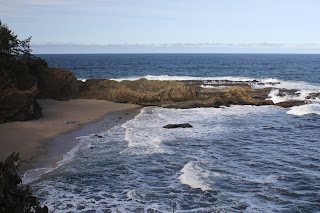
Low tide

High tide

It was low tide at the Cape Arago environs, the retreating ocean exposing reefs and rocky shoals to the airy elements. The booming waves at nearby Shore Acres are famed the world over but on this morning, they were barely making a ripple. The wind-driven whitecaps out to sea were larger than the waves lapping against the shore like a thirsty cat at a water dish. However, the ocean patiently bides its time and will once again rampage against the coastal ramparts come high tide.

Panorama of Simpson Reef 

From the gardens and viewpoints at Shore Acres, the coastal trail dipped in and out of the forest, sideswiping iconic landmarks such as Simpson Beach, before winding up at Simpson Reef Overlook. At the viewpoint, tourists and hikers alike can observe the sea lion bacchanalia and debauchery taking place on Shell Island. Replete with fishy smell, all that barking, belching, and farting was kind of like a gathering of through-hikers, but without the backpacks or hiking poles.

The forested path heading up to the Pack Trail

I'm not bragging (oh, but I am!) but I've lost weight lately and where I really notice the difference is when I'm hiking uphill. There is no direct trail from Simpson Reef Overlook to Cape Arago and one can either walk along the road to the cape, or cross the road and take the forested path leading to the Pack Trail. That particular path is a steep one but my lighter new and improved self just charged uphill, nearly as quick as a brand new Soul when the light turns green. Whew, did that ever feel good!

Lunchtime view

The coastal woods, fed by the perpetual fog at the cape, were predictably lush and verdant. The earthen track wound through the trees while numerous clumps of green ferns flanked the footpath. After reaching the Pack Trail, which is actually a gravel road, it was a short drop to Cape Arago herself, where we ate lunch while admiring the view of the sparkling sea and the rugged Oregon coast running to the south.

The sea was a bit more agitated on the way back

On the hike back to the trailhead, high tide was beginning to roll in and the waves were now a lot more entertaining than they had been earlier. We (John, Merle, and I) would see a huge wave break in spectacular explosive fashion, so cameras would be readied and then we'd wait...and wait...and wait for the next large wave. It apparently is a Cape Arago truism that waves are only spectacular when you aren't pointing a camera at them.

Pictorial definition of whitewater

The cool part about going home after the hike is I got to drive my new car all over again. Unfortunately, John and Merle took the occasion to pepper me with technical questions that I did not know the answers to, other than "Yeah, I'm pretty sure it has a motor". My ignorance of all things automotive was further exposed at my first fuel purchase when the attendant asked me to pop the gas tank lid open. Crap, how do I do that? Shaking his head in condescension and with a smirk on his face, the dude showed me where the lever was down on the floor by the seat. Hiking is so much easier!

A wall of solid rock, exposed by the low tide

For more photos of this hike,
please visit the Flickr album.

Monday, December 23, 2019

Cape Arago night hike


Pop! Hissssss... Those are the sounds of a murder. In this case, the helpless and hapless victim was the right rear tire on my Jeep and the perp was a hollow metal tube that impaled itself at right angles to the tire wall, neatly allowing the air contained within to escape in a mere minute. At least I know the tire sensor and dashboard indicator work. At any rate, Coral Rae, Daweson, and I were temporarily stranded in Myrtle Point by the slain tire, wondering if we'd even be able to do our night hike at Cape Arago.

My hiking companions

Bad weather had raised havoc with my plans to formally lead a group on a night hike and eventually the whole project was given up on because there was no way to get a weekend hike in this close to Christmas. The whole point of the night hike was to see the Christmas lights at Shore Acres State Park which is why the hike needed to be done before Christmas. Anyway, the weather eased up briefly on the Monday before Santa's arrival and spurred on by some friends associated with the South Coast Striders, a hiking group based in Coos Bay, I decided to go and secured the attendance of grandchildren Coral Rae and Daweson.

We started out later than intended

However, the Striders were beginning a bit later than I wanted to, so the kids and I left early, fully intending to hike by ourselves, ahead of our Strider friends. But a strategically placed metal tube in a comparatively soft rubber tire put paid to that idea and the end result was that because of time lost by the tire repair, we wound up at the trailhead at the same exact time that buddy Tom and his Strider companions were beginning their hike. It was like it was meant to be!

And so it begins

Starting at the unusual time of 4:00 pm, a half-dozen hikers or so set foot on the trail beginning at Sunset Bay State Park. The afternoon already had that pre-sunset burnished glow about it and despite the sunlight, it was what could charitably be referred to as "chilly". And, after a mile or two of casual hiking, the sun and sky looked more like sunset than afternoon. By the time we arrived at Shore Acres State Park, the Oregon coast was definitely basking in the last hurrah of daylight. The golden glow was perfect for photography and we mingled with the hordes of sunset shutterbugs gathered at the whale watching station, most armed with cameras at the ready with which to capture the sunset.

Christmas lights, courtesy of Mother Nature

Hiking quickly, we dropped onto relatively quiet Simpson Beach, and then walked through some dark woods to reattain the coastal bluffs overlooking the restless ocean. Grabbing a faint path took us atop a secluded rocky point where we all plopped down on grass to ooh and aah at the coming sunset. The day's denouement was mere minutes away so we didn't have to wait very long before day slipped into night to the accompaniment of the roaring surf. The orange sun coloring sky and clouds was Mother Nature's own version of Christmas lights.

Even the lights have lights at Shore Acres

Once the sun was down, it was time for the true "night" portion of this night hike. We whipped out the headlamps and flashlights and backtracked down to Simpson Beach, the waves barely visible in the fading light. And from there, it was just a short walk to the bright lights of Shore Acres State Park, the glow in the inky black forest advertising the Christmas light display from afar like the neon lights of Las Vegas do as you approach on a lonely desert highway.

Shore Acres at its Christmas finest

Shore Acres State Park goes all out for Christmas and the formal gardens were flamboyantly adorned with all manner of lights, colors, and Christmas motifs. The grounds were a fairyland of glowing colors and a choir serenaded visitors from a brightly lit pavilion. Neon frogs jumped from lily pad to lily pad in the reflecting pond and heron statues eternally stalked but never caught a school of koi statues that never swam away. And, as is its wont, the reflecting pond contained a mirror world of light and color living their lives underneath the surface. As far as the kids were concerned though, the highlight of the Shore Acres gardens was free hot cider and a peek at Santa enjoying a bubble bath in the caretaker's cottage.

Excuse me, I'm taking a BATH here!
(How we got on the naughty list)

I've been night-hiking in the Cape Arago area for many years now and often felt like I was the only one adventurous enough to do such a thing. However, in recent years, it has been a more common occurrence to encounter hikers walking from Sunset Bay to Shore Acres, their presence announced in advance by headlights bobbing and weaving like drunk fireflies in the forest. There's a really good reason to night hike, beside the fact that night hiking in general is an awesome experience, and that is because the traffic into Shore Acres is horrendous, often backing up for several miles. But the train of cars were nice enough to us to let us make a left turn out of the parking lot and we felt grateful and maybe a little bit smug at having avoided the long line of vehicles moving slower than we could hike in the dark.

Season's greetings!

For more photos of this hike, please visit the Flickr album.


Sunday, November 11, 2018

Yachats

In my view, one of Oregon's biggest mysteries is why Yachats is pronounced YAH-hahts but spelled like it should sound like YAH-chats. A cursory research conducted over the Internet (because if it's on the Internet, it MUST be true) revealed that the name possibly comes from the Siletz language and means "dark water at the foot of the mountain". OK, Cape Perpetua looms to the south of the small town so I get how that name could have originated. But when the first European first encountered the Siletz people and asked "What is the name of this place?", he probably got the answer "Yah-hahts". So then, said European writes in his journal "Yachats" and then from that point on, generations of Oregonians had to explain to their non-Oregon friends that the "c" is silent and as useful as a bubble-gum machine in a tetanus ward. Makes no sense to me at all, but there you go.

Abstract art found on the beach
Yachats is a quaint small town on the Oregon coast and because of the fantastic coastline scenery, hotels and house preside over shoreline vistas because we all know magnificent natural wonders need more hotels and tall buildings to enhance the view. At any rate, to get some mental health therapy that can only come from being out in nature and wilderness, I set out onto the Oregon Coast Trail and beneath my boots, welcomed the trail tread which felt a lot like...asphalt?

A churn erupts
OK, so this is not your wilderness hike. But one can look to the west and see rugged coast line and spouting churns, or one can look east and see Yachats. I prefer the view to the west. This hike began at Yachats State Park, where one can contemplate Cape Perpetua overlooking a small bay that is the estuary of the Yachats River. Immediately below were some fine tide pools with families enjoying the marine life contained within. Tidepooling is fun but I had a hike to do, so it was off on Ocean View Road, my hiking poles clacking metallically upon the pavement. 

Some of that Yachats shoreline
If I had looked closer at a map of the town, I could have ducked up 4th Street and added a park to my route but as it was, I just followed the Oregon Coast Trail signs which had me walking on public roads.  Suddenly, a dirt track appeared to the left and I grabbed it, thinking this surely must be the Oregon Coast Trail. Wrong, it was just a path down to the rocks and a small beach. Still thinking I was on the OCT, I continued over the rough shoreline terrain where a rambunctious churn at Agency Creek prevented me from safely continuing north. Still, the scenery was enjoyable so I didn't mind the wrong turn.

Yes, this really is the Oregon Coast Trail
The OCT continued north on roads until it became a paved trail that wandered behind backyards and houses. Beyond the Sea, a large hotel, loomed straight ahead but on the plus side, the trail followed the shore at this point without any asphalt being involved. I thought the hotel was oddly named because Beyond the Sea is Japan, which is easier to spell. Beyond Beyond the Sea was an even larger resort by the name of Adobe Resort which was strange, seeing how there are no adobe bricks within several time zones of Yachats. 

A perfect place for yoga and meditation
By the way, a brief moment of thanks to the two aforementioned hotels for allowing the Oregon Coast Trail to cruise between their imposing edifices and the Oregon coast. They didn't have to do that and sharing is appreciated. The next item of interest was Smelt Sands State Recreation Area, with some wild rock formations and picturesque tide pools filling up every dimple in the rocks. I can't say that I smelt anything unusual at Smelt Sands, though. Especially since Lane was not hiking with me, just sayin'.

The beach stretched all the way to Waldport
The trail left a lot of the urban feel behind when it ducked into a forest and dropped down on a beach that stretched out all the way to Waldport, about 10'ish miles away. The only hiking obstacle between me and Waldport was a wet ford across Starr Creek. From here on in, it would be a beach walk all the way to Tillicum Beach, my turnaround point. 

An ocean of silver
The beach was flanked inland by tall cliffs with imposing homes on them and after 4 miles, I had reached my beach saturation point. On the way back, the sunlight reflecting on a silver sea entertained and enthralled the camera, I have millions of photographs to support my claim of entrancement by the glimmering sea.

Boom!
I had been hiking in a rising tide and apart from an occasional wave chasing me up the beach every now and then, there was so much beach to hike on that that I was pretty much unaware of the incoming ocean. However, once back above the coast at Smelt Sands, the churns were very active with throngs of appreciative observers enjoying the show. Waves would surge up the narrow churns only to seemingly erupt out of the black rock at the end of the churn. It was quite a show and I soon forgot I was walking on an urban trail.

Shadow Man enjoyed the hike, too
All good things come to an end though, and I was tired and happy when I reached the parking lot at the end of the hike. Spending the day on the coast is always a good thing. For more photos of this hike, please visit the Flickr album.


Saturday, May 6, 2017

Blacklock Point

Blacklock Point is a frequent repeat customer hike of mine. Rinse, wash, repeat: Blacklock Point, over and over again, like a trail version of Groundhog Day. But why not? The coastline is particularly dramatic with imposing cliffs looming over a narrow beach, and the trail spends lots of quality shade time in between all the awesome viewpoints. Catch this little section of the Oregon Coast Trail in spring and you will be rewarded with impressive wildflower displays of rhododendron, lupine, iris, wild strawberry, and coastal huckleberry (see photo above). Frogs and newts populate the vernal pools covering the trail and naturally, feet get wet and muddy, always the sign of a great hike. Of course, catch the Blacklock Point and Floras Lake area in winter, and hikers will be "rewarded" with nasty wind and rain; been there and done that, too. But for me, the prime attraction is one clifftop viewpoint in particular that seems to get harder and harder to get to due to encroaching brush. But until it becomes impossible, as opposed to plain old very difficult, I'll take yet another spin on the Blacklock Point merry-go-round.

Yes, it was windy
I'm not the only one that feels that way, for The Friends of the Umpqua Hiking Club is also a frequent flyer to Blacklock Point and thus, an early May hike was scheduled there. It was time to get back on the Blacklock Point hamster wheel to renew my never-ending acquaintanceship with the aforementioned fantastic coastal scenery. Grandson Daweson had never been, though, so he was only too eager to come along with me.

Daweson demonstrates the proper technique
for getting past standing water
It was a gorgeous day at the coast. The sun was out, the sky was blue, and the trail was covered with deep puddles that were nearly ponds, or whatever is the next rank up from deep puddles. Well, two out of three isn't bad! When we arrived at the first puddle covering the trail, Daweson looked at me, and I at him, and without discussing the matter further, we simply splashed through like the two boys we are. Once across, we had to wait for our comrades to finish beating their way through the brush and side trails to get around. It's amazing the lengths people go through just to keep their feet from getting wet, like the Wicked Witch of the West was their podiatrist, "My feet are melting! My feet are melting! Oh what a world!"

The trail was newty

Snakey, too!
Newts and cute little baby garter snakes were in abundance on the wet trail, delighting amateur herpetologists and horrifying squeamish hikers with equal amplitude. Neither specie was afraid of the puddles, either. Anyway, after dodging puddles, newts, and snakes; we arrived at the junction with the Oregon Coast Trail and made the left turn toward Blacklock Point.

Into the deep, dark, woods
The woods were as dark and cool as a troll's lair, and I liked it. Shade loving plants like rhododendron and skunk cabbage thrived in the undergrowth just off trail. And just past an awesome backpacking campsite (I speak from personal experience), the forest ended and we walked out into bright sunlight, blinking myopically like so many cave newts. Sun and blue sky, it's finally summer: not! Despite the sunny day, a blustery arctic wind had teeth chattering in no time at all, while cuffing us around on the grassy cliff south of Blacklock Point. Jackets were quickly donned, and loose hats and caps were quickly doffed and stuffed into packs and pockets so they wouldn't blow away.  

View to Cape Blanco on a fine day
Despite the wind that made photography difficult (lets see you try to take a picture while staggering in the wind like a spastic marionette!), the views were awesome. To the south, the coast arced gracefully to Cape Blanco with the little bay bisected by the Sixes River and Castle Rock. Wind-driven whitecaps dotted the deep blue ocean's surface like a bad case of marine dandruff. I thought I spotted a tell-tale spout from a whale's blowhole but really, it could have been a whitecap too, it really was hard to tell the difference.

Yay,we got us some cliffs!
A short walk along the grassy edge of the Oregon world brought us to the Blacklock Point overlook. Directly below, reposed the black rocky crag of Blacklock Point itself, with a chain of islands dot-dot-dotting a stepping-stone path away from land. Normally, we stop longer to enjoy the view but the consensus was we all just wanted to get out of the wind. It really was cold!

This was the easy part of the bushwhack
So, back to the coastal trail we go and the next item on the itinerary was a clifftop viewpoint overlooking a waterfall. Rheo swears there is a path to the cliff but once again (this happened last year, too) we didn't see an obvious path. There was a less obvious path though, and for some reason, I found myself in front, leading the way for a pack of increasingly disgruntled hikers.

Straight down
The brush was thick and scratchy and we had to duck a number of scraggly tree limbs, the clawing branches seemingly intent on applying a tree tribal tattoo to the unwilling. The end result was we didn't get to the cliff Rheo wanted but we did manage to get to my favorite viewpoint in all of Oregon. Or, at least my favorite view until the next great view on the next great hike. 

No caption needed
The cliff here is orange dirt and is oddly barren. But oh, the view! The abrupt and cliffy edge of Oregon was visible for maybe about 20 miles or so with the sandy coastline curving north towards an unseen town of Bandon. And yes, we could see a bit of the waterfall, even though Rheo said the view thereof was cooler from the southern cliff. For some reason, nobody wanted to bushwhack over to the other viewpoint to the south. A hasty retreat was beat to tall grass, and lunch was eaten in an impromptu windbreak of grass and coastal scrub. 

Bushwhackers, and not all that happy, either
The enjoyment was short-lived however, as again I was designated like a Vibrum-soled and incredibly handsome Moses, to lead my people to the Promised Land, the sanctified destination in this case being a return to the trail. Yikes! I was familiar with the bushwhack route away from the viewpoint but the brush has really overgrown what was really a faint path to begin with. I knew I was about to get foul invective hurled my way when I had to butt-scoot, fully prone on my back, under a dense thicket of wind-twisted spruce trees. When we finally made the trail with most of us scratched and bloody, six-year old Emma (our youngest hiker) sported a toothy grin and gave me a high-five. "That was fun!", she said. I couldn't agree more, although most hikers agreed less.

A rock arch decorates the beach below
Our next little bushwhack venture further down the coastline, was to an overlook of a stately rock arch on the beach below. However, the bushwhack was nowhere as arduous as what we had done earlier, darn it. At this point, we split up into two groups with six mileage addicts following me further down the coast.


Trail through woods most excellent


The Oregon Coast Trail here peels away from the coast and follows an old road bed through a sublimely beautiful forest. The undergrowth was lush and green, and the tree branches overhead were as gnarled and twisted as a wizened hag's fingers, but enough about my ex-wife!. You could almost hear the Wicked Witch of the West cackle from the tangle of limbs "Come here, my prettys!". Then suddenly, we strode out into bright sunlight where we overlooked wind surfers flitting on and above Floras Lake, our turnaround point.  

Boots were harmed in the hiking of this hike
Daweson and I explored the beach a bit while the others headed back on the Oregon Coast Trail. The OCT had more puddles deep enough to nearly attain pond status. Frogs jumped into the water in panic but we could see them on the bottom, eyes closed and clicking their webbed heels frantically: "There's no place like home, there's no place like home, there's no place like home!" 

Cleared for takeoff!
Well the OCT portion of the route, while pretty and all, was over 3 miles long in returning back to the trailhead at Cape Arago Airport. At the airport, the proper and safe route calls for hikers to cross a field above the runway and return via the Blacklock Point Trail. But tired hikers and tired grandsons cheat and walk down the runway, nervously looking over their shoulders for incoming planes. As Daweson and I drove home to Roseburg, he started planning a return trip for his younger brother Issiah. Looks like Daweson, wants another ride on the Blacklock Point Twirl-a-Whirl, and I completely understand.

Rhododendron bugs me
For more pictures of this hike, please visit the Flickr album.


Saturday, June 22, 2013

Northrup Canyon


Northrup Canyon


I just can't think of anything funny to say about Northrup Canyon, located in Washington's hilariously named Channeled Scablands. It's just too beautiful. This little treasure of a hike is located in Steamboat Rock State Park (some websites refer to Northrup Canyon State Park but the official Washington parks website does not have such a park listed) and while most visitors climb the rock or frolic in Banks Lake's waters, one is not likely to encounter a lot of fellow hikers in this isolated canyon. And Northrup Canyon provided a good excuse to escape from family in Spokane and get a hike in.
Green-banded mariposa lily, as big as Cleveland


The hits started virtually at the trailhead as the canyon was eminently visible as I laced up my boots, slapping at the mosquitoes as I did so. The red-brown canyon walls evoked memories of the canyonlands of southern Utah. Large, or I daresay huge, green-banded mariposa lilies flanked the trail. Obviously, I was out of my normal Cascade Range milieu and this hike, for me, tended towards the exotic.


Basalt formation on the canyon wall
Following a jeep road on the canyon floor, the route dropped down into a surprisingly lush aspen forest flanking the small trickle that was Northrup Creek. Flowers bloomed everywhere and camera addicted hikers make slow progress up the canyon. The jeep road passed through a series of lush meadows where rabbits scampered in panic at my arrival. The canyon walls and rock formations loomed overhead while nesting birds squawked at me from caves above.

Needs a little fixing up
At the last of several pastures, there are the ruins of several abandoned cabins marking the site of an old homestead belonging to the Northrup family that settled this canyon. A passing hiker told me park rangers used to live there years ago. However, the cabins are dilapidated and falling apart and well beyond being habitable, even for park rangers. A large pile of rusting tin cans showed where the garbage pit used to be.

Skyrockets in flight
The jeep road ended at the homestead site and from here on in, it was happy hiking on a real trail, a rocky footpath that headed up the canyon. The trail was an up and down affair with more ups than downs. The vegetation changed from green pastures to dry high desert sagebrush. Bright red skyrocket nodded over the trail while yellow was well represented by groundsel and golden yarrow.  Bugs crawled all over the flowers and it was slow going as I attempted to take a picture of every bug and every flower.

Northrup Lake
As the trail climbed, brief side trips took me to overlooks of the impressive canyon. Eventually, I ran out of canyon at Northrup Lake, a small pond at the canyon head. Not much to do but turn around and head back, completing a short but spectacular 6 mile round tripper while the sunlight faded.

Golf, anyone?

This is a classic hike in eastern Wasington, and I'll have to come back, maybe make Dollie come with me. I took a ton of pictures on this hike, you can see the chosen few (ha!) in my Flickr album.