Showing posts with label Seven Devils State Recreation Site. Show all posts

Saturday, February 10, 2018

Bullards Beach to Seven Devils Wayside

That's it, I quit! No more hiking inland! Lately, every time I hike in either the Cascades or the Siskiyous, the weather's been rainy, cold, or all of the above. In contrast, almost every time I've hiked at the coast in the last few months, the weather has been absolutely glorious with spring time sun shining brightly with perfectly mild temps. The latest case in point was a recent hike from the Coquille River to Seven Devils State Recreation Site (which is just a glorified name for "picnic area on Seven Devils Road").

Between the Friends of the Umpqua and the South Coast Striders (a sister hiking club from Coos Bay), we had nearly 20 hikers presenting to arms. By the time we showed at the meet-up point at Seven Devils, the Coos Bayliens had already worked out the intricate machinations of the vehicle shuttle. By way of explanation, the shuttle process was required because this was a one-way beach walk of 8.2 miles with drivers needing a ride back to their vehicles at Bullards Beach after the hike was over. We left a couple of cars at Seven Devils for that express purpose and began hiking from the Coquille River and its attendant lighthouse and river jetty.

This fossil found a fossil
The lighthouse used to be sited on an island in the middle of the river entrance but man in his infinite wisdumb, constructed a rock jetty to shepherd the river safely out to sea. The normal oceanic shoreline currents were interrupted and impeded by the jetty, with the result that backfill soon connected the lighthouse's island to the shore. I think that also as a result of this particular instance of man tampering with nature, is that Bullards Beach is always (within my experience, at least) littered with rocks that make this beach the beachcomber's equivalent of a yard-sale addict with $500 to spend at an estate sale. 

Sanderlings do the wave dance
Well, it didn't take long for me and several other beachcombing like-minded individuals to start walking slower, eyes carefully scanning the ground for beach treasure. Directly related to said activity, my pack soon weighed more that it did when I had started hiking, due to my toting a healthy sampling of clam fossils and petrified wood. My buddy Jay was similarly afflicted and burdened.

Our basic view for 8 miles
Although a cool breeze was a constant and the temps were somewhere in the low 50's, the sun was out and there was no chance of rain. The Oregon coast stretched out in front of us and we could see all the way to Cape Arago. I told Jay we were hiking all the way there because it was  so much fun to hear him cry with dismay.

The tide was out, to put it mildly


The tide was receding and by the time we reached Cut Creek at the 4 mile mark, we had acres of sand to walk on as the ocean had sullenly withdrawn from all beach proceedings. Tidal flats and sand bars were exposed by the retreating sea, and there was more slow walking due to some more obligatory beachcombing. There was probably like 40 or 50 yards of wet sand that was firm enough to provide a nice hard surface for easy hiking.

Jay ponders how to cross without getting feet wet
The next landmark after Cut Creek was Whiskey Run, a medium sized creek that sinuously S-curved its way to the much larger ocean. A pair of kite surfers were doing their thing in the choppy surf while fisherman were filling up their buckets with perch, enjoying peaceful beachy solitude as they plied their avocation. At the water's edge, flocks of sanderlings comically darted in and out, matching the ebb and flow of the waves.

Tidepool scenery at Fivemile Point
About a mile past Whiskey Run, Fivemile Point seemingly blocked the way. Now, I've hiked around the point a time or two, but always on a receding tide. In each instance, it had been tricky scrambling over the rocks while waves tried to eat me. But ah, at low tide, no such issues at all, it was merely a simple walk around the point.

Exposed shoals at low tide
Well, maybe not all that simple, for the retreating tide had left numerous tide pools that just called for exploration and photography. Jay and I, who were already lagging far behind the main body of power-hikers, soon lagged even further behind but on the other hand, we both have lots of photos of the scenic pools and rocky islands at Fivemile Point. 

Twomile Creek beelines for the sea
Even though it is only a mile further past Fivemile Point, the creek there is called Twomile Creek. Around here, they must use the metric system when naming their landmarks. But Twomile Creek marked our exit point off the beach and the end of this 8.2 mile beach walk. We all really enjoyed this sunny day on the coast, made perhaps even more memorable by comparison to the next day's hike in a swirling snowstorm on the North Umpqua Trail. Seriously, I'm just going to hike at the coast from here on in.

Nice haul!
For more pictures of this hike, please visit the Flickr album.


Saturday, October 7, 2017

Merchants Beach

Seems like the Friends of the Umpqua hiking schedule was about as solid and permanent as a sand castle at high tide. The wildfires this summer had us all scrambling and rearranging destinations due to closures, smoke, and outright fire on or around our favorite trails. The upcoming hike was scheduled for Rattlesnake Mountain but the Rattlesnake Fire kind of got in the way of that. What an amazing coincidence to have Rattlesnake Fire burning on Rattlesnake Mountain, what were the odds of that happening? Naturally, there wasn't going to be any Rattlesnake hiking but the Forest Service made it official when they closed not only the Rattlesnake Trail, but the entire Rogue-Umpqua Divide Wilderness.

One misty moisty morning...
Hike leader Diana was incommunicado while enjoying a fire-free vacation in Spain, so yours truly made an executive decision and changed the destination to Sacchi Beach. I'd been there a few weeks earlier but the club hadn't hiked there that I knew of, Sacchi Beach would be a new destination for most hikers. Plus, the odds of a Sacchi Fire taking hold on the beach were pretty slim. In hindsight, I should have checked the tide tables first, but what's a Richard Hike without a little chaos involved?

Morning constitutionals
Fifteen hikers, one dog, and one drone showed up on a misty morning for a nice beach walk. Turned out, high tide was due to crest in about 90 minutes but there was plenty of sandy beach as we started. There are three beaches involved when hiking from the Seven Devils State Recreation Area: Merchants Beach lies north of Fivemile Point with Twomile Creek roughly marking where Agate Beach begins. Agate Beach ends at an unnamed point, with Sacchi Beach laying on other side of the point. Got it? There's going to be a pop quiz in the morning, kids, so be ready.

The hike north ends here
At any rate, we traversed Agate Beach, reaching the unnamed point in short order. The waves were already lapping at the base and a quick climb up some rocks revealed the bad news: there would be no hiking on Sacchi Beach today. At best the water was near knee deep and of course, it was much deeper when the waves rolled in. 

C'mon sun, you can do it!
So back south we went, as the mist lifted and returned, seemingly ebbing and waning with the waves. However, the trend was generally heading towards a sunny day. The hike back to Seven Devils was pretty short so most hikers continued on south towards Fivemile Point. A flock of vultures watched us from a stand of dead trees, licking their beaky lips as they watched their lunch walk by. It always makes me nervous when the vultures do that, what do they know about my life expectancy that I don't?

The hike south ends here
When Issiah and I hiked to Fivemile Point earlier this year, we scrambled over Fivemile Point by clamboring over the rocky point. While hands were required, the scramble up and over wasn't too difficult, although Issiah seemed to have less difficulty climbing over than I did.  But with the incoming tide clasping the point in a watery embrace, we couldn't even reach the point where the climb over began. What we were left with were damp and sheer cliffs, and the realization we weren't going to get past Fivemile Point either.

Who says an old dog can't teach new tricks?
A long and leisurely lunch break was enjoyed at the point, the seaside scenery entertaining us as the sky morphed from gray to blue. Oddly enough, a rusting engine block lay in the sand at the base of the point, leading to much speculation as to how that block got here in the first place. My theory is that it was dropped there by the world's strongest osprey.

Beach treasure, in the form of petrified wood
All good things come to an end and reluctantly, we strolled back to the car, having to be satisfied with an easy 6 mile hike. Maybe next time I'll check the tide table before deciding on a beach hike. But it could have been worse, we could have been hiking in the middle of a wildfire on Rattlesnake Mountain.

Sure beats walking in a forest fire
For more pictures of this hike, please visit the Flickr album.


Friday, September 1, 2017

Sacchi Beach

I've never felt the need to smoke. In my view, there's just no appeal in burning a stinky weed in your mouth. The whole allure of smoking simply baffles me, I just don't get it. I try not to get too judgmental about those who do smoke because I have friends and family members who smoke and apart from that one fault, are generally pretty nice people. But I do think second-hand smoke is pretty rude because somebody else's smoking habit is being imposed on me against my will. So, imagine my discomfiture when in the month of August and early September, I had to unwillingly inhale unfiltered smoke all day and every day. I'll probably wind up with some lung disorder later on in life, directly attributable to the fire smoke that filled up the valleys of western Oregon in summer of 2017.

Mid-morning in Winston
Near Roseburg, we had the North Umpqua Forest Complex fires vaporizing thousands of acres of trees along the North Umpqua River. The complex included the Happy Dog Fire happily burning up the forest in the Boulder Creek Wilderness area. Bad doggie! Poor little Boulder Creek is like Lightning Central when the summer storms commence and can't even get a baby forest started due to the frequent fires in the area. Yet, despite the lack of live trees, the fires somehow still find plenty of fuel to burn.

Cough!
However, the North Umpqua Forest Complex was not alone and had plenty of flaming company: The Falcon Complex and High Cascade Complex fires managed to shut down the Rogue-Umpqua Divide Wilderness and the north and west sides of Crater Lake National Park. Further south was the Miller Complex, gloriously denuding the slopes of Red Buttes Wilderness and Grayback Mountain. Nearer to home, the Horse Prairie Fire chewed up the oft-burned Lower Cow Creek area near Riddle. But the star of the smoke show was the Chetco Bar Fire which at the time of this writing (September 19th) was rapidly approaching 200,000 acres of ashy terrain as its legacy. 

Our view, for six straight weeks
During late August and early September, the weather had been hot and dry, with little or no wind movement. So, the fires churned and burned and the resulting smoke filled up all the low-lying valleys. The smoke had no other place to go, yet the fires continued to pump more smoke into the already smoke-filled low areas to the point where the sun was not visible at all in the dirty brown sky. The vibe and atmosphere was apocalyptic and I'm going to start smoking whether I like it or not.

Twomile Creek, on a fine day a the coast
However, the weekend forecast did call for some relief at the coast with winds predicted to sweep the Chetco Bar Fire smoke and ash in a northeastern direction. The city of Bend was the lucky recipient of our smoke, but I was OK with that, even though Bend wasn't, as I headed out to the coast to see if blue sky was what I remembered it to be. On the drive over the Coast Range, the air near Coquille was nearly solid with fresh particulate matter that left parked cars coated with ash.

Agate Beach beckons
At Seven Devils State Recreation Site on the Oregon coast, there was some blue sky, although there was still plenty of smoke graying up the sky to the south with a noticeable layer of smoke hanging high over the ocean. Given the recent six-week long nastiness of the air quality (or lack, thereof), I'll take it. As I set out on Merchants Beach, a chill wind blew into my face, it was so good to feel air movement, too.
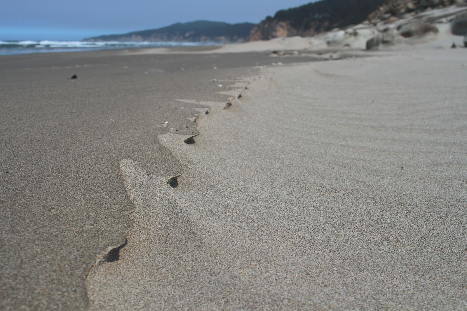
Sand art
This hike would be a tale of three beaches: Merchants, Agate, and Sacchi. Merchants and Agate Beach are basically the same strip of sand with Agate Beach kind of hanging around Threemile Creek and Merchants Beach hanging around Twomile Creek. An unnamed rocky point keeps Sacchi Beach pent up in its own little beachy corner of the Oregon coast.

Miniature wind hoodoos
Heading north to Agate Beach, it was several miles of a lonely strand of sand arcing towards a distant Cape Arago, with only gulls and sand crabs to keep me company. The wind had created miniature formations out of the numerous pebbles on the beach, from an ant's-eye view, they probably resembled hoodoos and balancing rocks. Occasional rocky cliffs sported interesting rock formations and one rock in particular resembled the fossilized skull of the Aztec god Mictlantecuhtli.

Eroded rock at Sacchi Beach
The tide was receding at the unnamed point, so there were no interesting wet-footed tales to tell: just a simple dry-footed stroll around barnacle encrusted rocks to secluded Sacchi Beach. After a mile of walking along the sand, the beach abruptly ended at a formidable cliff that delineated where Sacchi Beach ended and Cape Arago sort of started. The tide was way out, exposing some phantasmagorical rock formations. More dear to my heart, a sandy maze of a route through the rocks provided a way to explore further north along the shore, leading me to a secret cove.

The secret cove was a wild place
This is not the place to be in high tide and even though it was low tide, a wave rolled in and left me stranded atop a rock, waiting for the water to recede so I could safely leave the secret cove. While waiting, I availed myself of the opportunity to take pictures of the rocks, islands, and a notable amphitheater carved into a massive cliff by the waves. This little piece of Sacchi Beach was my favorite part of the hike.

Creepy ball of sand crab babies
On the way back, the tide had receded farther than a middle-aged man's hairline, exposing acres of beach glistening under the afternoon sun. The scenery was pretty and all, but this portion of the hike soon became all about the sand crabs. As waves ebbed, dozens of sand crabs emerged from the sand and scurried after the retreating water line before hurriedly burrowing back into the sand. Large balls of baby sand crabs rolled in the shallow water, creepily scattering hither and yon at my arrival.

Rock warts


At about the 5.6 mile mark, I had made it back to Twomile Creek and the picnic area at the Seven Devils Recreation Site, but I wasn't done yet. For more mileage, I walked to Fivemile Point and back. The sun was getting low and the restless sea glinted silver in the afternoon sunlight. Fivemile Point was totally exposed by the low tide and I was able to take photographs of concretions and eroded honeycomb formations on the rock.

My route 
From Fivemile Point, it was a lean-into-the-wind hike back to Seven Devils picnic area, as a flock of rather nonchalant and blase seagulls blithely watched me walk by. There was a critter track that ended abruptly in the wet sand, so I started digging to see what made the track. When some wiggling wormy creature from the depths started flipping around in my hand unexpectedly, I may have screamed a little.

Behold the fossilized skull of Mictlantecuhtli!
It was nice to spend at least one day this summer under semi-blue sky and I was a happy hiker on the drive home. Well, I was happy, until I reached Coquille and the smoky air. The Horse Prairie Fire was still burning and more smoke was being pumped into the Coquille River valley. Looks like I picked the wrong day to quit smoking!

Sacchi Beach rocks!
For more pictures of this hike, please visit the Flickr album.