Showing posts with label Belknap Hot Springs. Show all posts

Friday, October 15, 2021

McKenzie River Trail (from Belknap Springs)

No matter how meticulous or painstaking the planning, sometimes things just do not go as intended. Improvisation is often the saving grace of a given hike and the unpredictability makes hiking fun, as long as it's good unpredictability. An unexpected trail closure that forces you onto a trail you'd never been on can be an enjoyable adventure, as long as you don't do something stupid like twist your ankle on the new trail. Gratefully, no body parts were injured on this hike, but because my intended route on the McKenzie River Trail was closed due to wildfire damage, I was forced mid-hike to come up with a new plan on the spur of the moment.

The cold and forbidding waters of the McKenzie

Uncharacteristically (for me), the hiking festivities started early morning, the sun had not yet risen high enough to shine down into the river canyon. Winter is coming and dang, it was cold. I could barely feel my fingers and the cold air made me rue my newly shaved head. If my ears could talk they'd be clamoring for me to immediately don a ski cap before they freeze and fall off my hairless head.

Autumn decorates a bridge railing

Initially, fallen trees covered the trail so I improvised (theme of this blog!) by walking down to Belknap Hot Springs Resort and then through the nearby campground full of still snoring campers. A short cross-country walk from an empty campsite then put me on the McKenzie River Trail proper, where the campground "scenery" was exchanged for a forest lush and light green, the understory being comprised of dense vine maple growth just starting to turn yellow.

The river takes a moment to
reflect on the meaning of life

The McKenzie River was nearby, which only makes sense, given that I was hiking on the McKenzie River Trail. The river surged dark and foreboding in the deep shade, the waters exuding an icy aura that did not even come close to inviting a refreshing swim. In the quiet parts, the surface of the river was like polished onyx and the autumn colors and what little sunlight there was reflected on the river and artfully colored it up. 

Bridge crossing at Boulder Creek

In quick succession, a pair of rustic footbridges crossed over an unnamed creek and Boulder Creek. The unnamed creek's bridge was one-railed, causing me to place an inordinate amount of trust and faith in my left hand and arm. Boulder Creek's bridge has the proper amount of rails (two!) but the creek had very little water pooling between the many boulders in the creek bed. I could see where Boulder Creek joined with the McKenzie but the unnamed creek just disappeared into the rampant greenery encroaching the creek bed. And thus ends this random tale of two creeks which much like this hike, rambled aimlessly.

A moment of Zen

I knew the Knoll Fire had trashed the McKenzie River Trail at Deer Creek, causing the Forest Service to close that section of trail. What I did not realize was that the line of demarcation for the closure was not at Deer Creek itself, but at Deer Creek Road instead. That closure site meant that my intended 8 mile hike was now going to be a 4 mile hike. The barrier itself was just a wooden sawhorse with no explanation attached and I could hear my hiking buddies saying "If you can walk around it, it's not closed!' (We had discussed trail closures on our last hike). But I believe in playing nice with the USFS, so it was back the way I had come, pondering how best to come up with some additional mileage.

Sunlight filters through the leafy woods

Duh, the McKenzie River Trail runs in either direction from Belknap Springs Trailhead. So once I reached the trailhead, it was a simple matter of crossing the road and continuing west on the trail. Now, my preconceived notion was that this trail section basically hugged busy McKenzie Highway and was generally uninteresting. Boy, was I wrong, wrong enough that I am even putting it in writing right here in my blog.

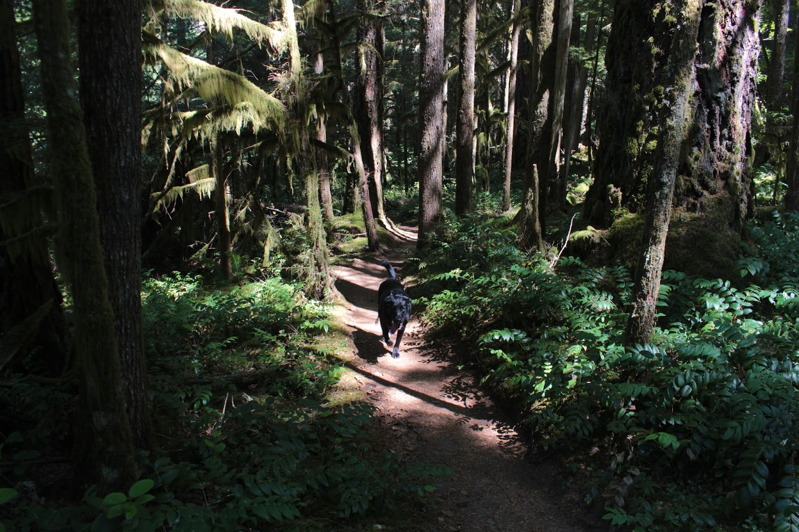
The trail wound its way through an
entrancing and captivating forest

The forest on this part was beautiful and eminently sublime. Ample greenery abounded, although the greenery was not entirely green-leafed, thanks to vine maples turning yellow or red, depending on the sunlight. Lush growth flanked the trail, the usual suspects being Oregon grape, salal, and all the ferns you could ever hope to see on a day hike. Not to mention, tall maple and conifer trees kept the hike shady and whatever sunlight made it down to the forest floor was of the dappled variety. 

Arrival at Lost Creek

The trail rapidly descended down a forested ridge crest that peeled away from the now unseen river. My reward for all that downhill hiking, besides having to hike back up, was a scenic bridge crossing at Lost Creek. The creek didn't look all that lost, as it joined the McKenzie within eyeshot of the bridge. The stream coursed in the bottom of a pronounced canyon and was nearly wide enough to be considered a river. The bridge seemed a good place as any to turn around at, and back up the trail I went, happy with the discovery of another totally awesome hike, thanks to an unexpected closure and some improvisation.

This portion of the McKenzie River
Trail invites further exploration

For more photos of this hike, please visit the Flickr album.

Sunday, June 23, 2019

McKenzie River Trail (Boulder Creek to Deer Creek)

This little section of the McKenzie River Trail is one of my summertime go-to hikes. The route is perpetually shaded for most of its eight miles or so, numerous creeks cross the trail, the forest is eminently green, and the McKenzie River makes frequent appearances with each break in the vegetative cover. Because the bottom of the river canyon is well shaded, the temperatures tend to be cooler here than in our urban areas sprawled next to Interstate 5. Also, the trail is blessedly flat for the most part, making the hiking both easier and cooler, especially on a baking warm day. So, let's hike already!

Candystick, flowering away
Despite the allusions to baking hot days, on this day the temperature was fairly mild, so the purpose of this hike rendition tended more towards sheer enjoyment of the river and shade and not at all towards frantic relief from the brain-parboiling heat of summer. Normally, I begin this section of the McKenzie River Trail from the resort at Belknap Hot Springs, but just to do something different this time, this hike commenced from the road bridge spanning the river near Boulder Creek. That way, I could make it as far as Deer Creek, which would be a whole new trail experience for me.

This small creek is actually part of the McKenzie River

Regardless of the new starting point, it was still the same old river, forest, and shade, and it felt wonderful. The path basically followed the river and rustic footbridges crossed several small creeks that were in no real hurry to meet up with the McKenzie, judging by the languid pools reflecting the low light within the forest. The canopy of mostly vine maple leaves let in very little light and the ample leafage imbued the very air with a soft green glow.

Tiger lilies prowled the trailside brush
While the creeks were in no particular hurry, dozens of women were very much intent on speeding down the trail with as much alacrity as they could muster. Seems there was a nearby women's retreat that also involved a trail run event. Me, I would retreat from any retreat that boasted a trail running event, that looked like way too much work. Besides which, I'd be sure to roll my weak ankles at some point, always a miserable occurrence. Also, despite exchanging cheery greetings with me, not all of the participants had facial expressions that said they were enjoying their more frenetic pace along the trail.

The McKenzie River Trail followed a forest road for a bit


At about the mile mark, the trail inscribed a switchback in the opposite direction and headed uphill to a forest road that is the actual McKenzie River Trail, gravel road appearance notwithstanding. After going under some power lines the road then descended back down to the river, that little detour making no sense to me at all. At any rate, the hike returned to the more comfortable milieu of fungus, flowers, and forest.

Bridge, leading from light unto dark
At about the 2.5 mile mark, the trail crossed Frissell Creek on a stout wooden bridge and from here on in, it would be all new trail for me. Underneath the bridge, the small creek flowed on its way to the river, the waters of the creek coursing amazingly clear.


Where the McKenzie divided around an island
After crossing Frissell Creek, the trail tended to stay fairly close to the river. Because of the thick forest and vegetation, it was not always easy to get the "big picture" of what the river was doing. At times, it seemed that the water flowing below the trail and through the trees had to be a creek instead of the river, although no creeks were nearby according to my GPS. The mild mystery was solved when  the river clearly divided around a heavily wooded island, sending a much smaller volume of river water on the trail side of the island just to confuse me.

Backpacking sites called to me
At a large bend in the river which was hidden from sight by the forest, the trail went high into the woods and temporarily left the river behind. At the four mile mark, the trail crossed a paved forest road before sideswiping a nice backpacking campsite next to the bridge at Deer Creek, The campsite was one of several seen on this hike and all of them were fairly luxurious when compared to my usual meager camping spots when backpacking. I really must come back and backpack the full McKenzie River Trail sometime, but I digress.

The well-engineered bridge at Deer Creek
Deer Creek has carved a rather large and deep valley in the surrounding mountains so I really was expecting a creek commensurately sized to match the geological terraforming. However, the reality is that Deer Creek was just a small creek, nothing more than any of the other creeks already encountered on this hike. The wooden bridge crossing the creek was more impressive though, spanning the comparitively wide canyon. Because of the width of the bridge, it shook and swayed in the middle as I walked across.

The texture of Deer Creek
Deer Creek made for a logical turnaround point, and I ate a quick lunch there while meditating upon the reflecting pools of the small creek. After that, it was back the way I had come, with the same enjoyment of forest, shade, river, flowers, and fungi. By this time, the other side of the river was bathed in sunlight and the bright reflections rippled zen-like on the pools of the various creeks running across the trail.

Sparkling clear water on a small creek
By this time, the last trail runner had long passed by but I still had to step aside every now and then for mountain bikers trundling past. Unlike the trail runners though, their facial expressions said they were enjoying their ride. I couldn't see my facial expression of course, but hopefully it was adequately conveying how enjoyable this hike had been.

My view for most of eight miles
For more pictures of this hike, please visit the Flickr album.


Saturday, October 21, 2017

McKenzie River Trail

When I got up in the morning, the rain was just pouring down in sheets, loudly pelting the living room windows and disturbing the cat's sleep. "Watch", I told Dollie "I really don't want to go hiking today but there'll be three morons at the parking lot and I'll have to lead the hike anyway". John was the first to show and he said "Good morning, Richard" and I replied "One moron, two to go" Number two presented arms a few minutes later when Diana arrived. And right on cue, Lane appeared seconds before deadline. "Three morons, I called it", my hostile-sounding remark eliciting a puzzled look from Lane.

The Moron Hiking Club is now called to order
Lane picked up Ceresse in Springfield and after initiating her as an honorary member of the Three-Moron Club, we then headed up the McKenzie Highway, 5 intrepid hikers strong. The original plan was to hike around Clear Lake but I was watching the temperature gauge and it was just a few degrees above freezing. The east side of Clear Lake is all exposed lava fields and the idea of hiking through that in a rain/slush/snow combo just didn't sound very appealing. After a quick roadside confab, we made the impromptu decision to hike on the McKenzie River Trail instead. The thinking was that we'd see the fall colors that make the McKenzie River area so spectacular in October. Plus the thick forest would possibly provide some protection from the rain. 

Diana crosses Scott Creek
It was really pouring and it was cold. That about sums it up, weather-wise. The raindrops were heavy and fat, it was like being pelted by ice-cold water balloons without the balloon part. It was so wet that even the salmon stayed indoors. The overhead forest protection delayed the inevitable in that we were soaked within 5 minutes instead of immediately. Ceresse was heard to mutter to Lane about me "Doesn't he know that we could have mall-walked instead?" What, and miss all this?

Soggily spectacular
Rain notwithstanding, the vine maples were out-of-this-world spectacular. The maple growth underneath the tall firs was thick and profuse and all of it was tinted some variation of bright yellow. The day was dark and gloomy, yet the forest seemed to glow with a gold light from within. I'd like to say the fall colors were so spectacular that we forgot all about the cold rain but no, it was so darn wet we could not help but wonder what the heck we were doing out there.  Oddly enough, we never saw another hiker all day, not sure why that was. Come to think of it, we didn't see any mountain bikers, equestrians, or river rafters, either. Not even deer, raccoon, or newt; just us, all alone in the wet woods.

Trail shot


After nearly two miles, we crossed the McKenzie River on a road bridge and the trail was less groomed and more like a real trail. Meaning, the low spots in the trail were full of water and that was where I found out I have worn a hole in my boots. Oh well, at least my feet were wet and cold, didn't want them to miss out on all the watery fun. It was somewhere around here that I removed the camera battery and stored the camera in a waterproof trash bag for safety's sake.

You have to admit, it is an unbelievable display of color
I began to sense waning enthusiasm from my charges, a subtle sign of such was when Diana, Ceresse, and Lane turned back, each telling me in no uncertain terms I am no longer on their Christmas card list. Plus, my phone number has been blocked and they are not answering my text messages. John, though,  was still up for more and I figured he and I could turn around at the intersection with the forest road, winding up with a soggy 6 mile hike. As we continued on, the puddles became deeper and deeper, along with increasing frequency. Eventually, the trail was just one long continuous puddle and my cold wet feet got colder and wetter, if such a thing was possible. After all the spectacularly wet trail miles, it was almost anticlimactic when we turned around at the nondescript gravel road, but at least we got to splash through the puddles all over again on the way back.

Trail through the golden arches


I wound taking just 36 photos, a far cry from the 597 photos I brought home from the Upper Rogue River. I also wound up with 55 pounds of wet day pack, boots, socks, and other assorted clothing, but at least the camera still works. Once inside a dry car with the heater cranked up to full, we all stated that we enjoyed the experience and that we all felt sorry for all the people cooped up in their homes, foolishly staying out of the rain. Yup, we were 5 pretty proud morons!

A river and yellow leaves just about sums it up
For more pictures of this hike, please visit the Flickr album.


Sunday, July 16, 2017

McKenzie River Trail


Ah, what a relaxing trail (unless you lose your dog!) this little section of the McKenzie River Trail is. Miles and miles of vine maples providing ample shade, tall Douglas fir trees reaching to the sky, a rushing river just off trail, and rustic bridges crossing merrily burbling creeks. If that doesn't ease your stress, nothing will. Of course, some of that stress release was negated by the worry caused by a missing dog, but more on that little episode later.

Twinkling green stars overhead
Luna (the aforementioned bad doggy) and I set out from Belknap Hot Springs Resort and were immediately rewarded with a lush and cool forest. The day was hot everywhere else in southern Oregon but the river moisture in the air; the shade from the trees; and a mild breeze, kept hikers and bikers cool. If word ever gets out about this, there'll be hundreds of thousands of people sitting under the trees, sighing contentedly in blessed relief from the heat wave currently cooking the Pacific Northwest. 

Indian pipe
The McKenzie River Trail (hereafter referred to as the MRT because it's too long to type out over and over again) is a National Recreation Trail, because it contributes to "...health, conservation, and recreation goals in the United States." To which I ponder "But don't they all?" but that's just me talking. At any rate, the MRT is close to Eugene, easily accessible from the McKenzie Highway, and proffers up  some pretty cool scenery and a classic river flowing just off trail. Mountain bikers love the trail and hikers have to get used to stepping aside for the bikes but in my experience, both hikers and bikers are polite and get along just fine. The main drawback to the MRT, in my humble opinion, is that the trail lacks that wilderness feel.

The McKenzie River Trail soothes on a warm day
For the first section from Belknap Hot Springs, the trail parallels the nearby McKenzie Highway. The sound of whooshing cars is clearly audible but if you plug your ears and/or ignore the sounds, the forest is simply beautiful. Small little side creeks rush into the McKenzie River and rustic one-railed log bridges span the creeks. I crossed the creeks on the bridges while Luna joyfully splashed across, as is her wont. And speaking of rushing into the the McKenzie River, Luna did plenty of that too.

Hey you! I'm taking a picture of you!
We stopped for a brief view-soak on a rocky bar next to the river. The McKenzie River gets its inception at the remarkable Great Spring at Clear Lake; the spring being noteworthy for the striking blue color and crystalline clarity of the water. As the Great Spring's love child, the McKenzie River sports both these traits. Rafters came through the rapids above the bar, intensely focused on navigating the roiling river and on keeping their crafts right side up. That's probably why they didn't wave at us or smile for the camera.

Bridge crossing at Scott Creek
After a couple of miles, the trail crossed both Scott and Boulder Creeks and then spit us out of the forest and onto the shoulder of the McKenzie Highway. Like I said, not really your basic wilderness hike. But not to worry, after about 20 yards, the route crossed over to the other side of the river on paved Forest Road 2560. Now that there was a noisy river between us and the equally noisy highway, we enjoyed that "real hike" ambience that can only be found on a forest path. We still had to step aside for a steady stream of mountain bikers, though.

The McKenzie River was always next to the trail
Mostly this hike was all about the forest as the river was only occasionally and partially visible through the dense stands of vine maple. There was no particular destination to hike to, although Deer Creek would have made a logical turnaround at 6 miles out. However, we turned around where the McKenzie divided around a rocky island at the 4 mile mark.

Bad doggy!
Luna had been such a good dog, too. She had stayed within eyesight and dutifully obeyed my commands to stay close. But she has no filters for right and wrong, and is as impulsive as a late-night tweeter. Just like that, she was no longer visible ahead of me and I really wasn't sure when or where she had disappeared from sight. I assumed, because she walks a lot faster than I do, she had gotten far out in front of me so I picked up my pace trying to catch up to her.  After a mile or so, it was obvious she was clearly lost from me.

Vine maples doing the vine maple thing
Worried at this point, I even turned back and walked the mile back but still no Luna. Sick at heart at the thought of her having to be all alone in the forest, my next plan was to walk to the car and wait to see if she'd show up or not. If that proved fruitless, I had no plan for what to do afterwards. 

Cold and clear, just like me!
The MRT is a busy place with all the hikers and bikers but of course, I walked for miles and miles without seeing a soul. Finally, after I crossed over to highway side of the river, a family came walking up the trail. Unfortunately, they hadn't seen a stupid black dog walking by herself. They were really quite sympathetic to my plight and as they commiserated, their son interrupted "Mister, is that your dog?" and here comes Luna trotting down the trail, relief palpable in her body posture.

Huckleberry, not quite ready for eating
Mind you, we had been separated for at least two miles. She had to navigate past two trailheads, cross one forest road, follow a paved road across the river, and safely walk next to the highway before she caught up with me. Quite a testament to her innate navigational ability. Or, if she followed me by sense of smell, quite a testament to my man-funk! Either way, our reunion was joyous and she remained leashed for the remainder of the hike. She'll probably remain leashed for all future hikes, too.

Sun dappling
No longer toting that cold orb of dread in the pit of my stomach, the remainder of the hike was much more relaxed as we returned to Belknap Hot Springs. I did notice though, that when Luna found me, she was soaking wet. She couldn't have been all that worried if she still could indulge in another dip in the river. The stress was all mine, apparently.


The McKenzie River
For more pictures of this hike, please visit the Flickr album.


Saturday, March 24, 2012

McKenzie River Trail


March was so crazy, weather-wise.  It rained, it snowed, it rained some more to the point where all of Oregon was suffering from mass Vitamin D deficiency.  There was probably a lot of season-affective disorder too, making us hikers very irritable, in particular.

Hi ho, hi ho, it's in the snow we go
A brief break in the precipitation called for a low-elevation hike; the McKenzie River National Recreation Trail was selected because my guide book said it was hikeable all year round.  Oops, that should have read "...hikeable all year (except for 2012) round".


Vive le McKenzie


We parked our car at the Belknap Hot Springs Resort and headed up the trail.  Within a few yards, we ran into snow at a mere 1500 ft of elevation.  However, the snow was just inches deep and the trail was always visible.  Also, mostly-always visible was the noisy McKenzie River, running deep and cold with the winter runoff. 

Avoiding a wet spot semi-successfully


Water was all over the trail in the forms of snow, standing puddles, and running creeks.  Fortunately, this trail receives a lot of love and the many footbridges kept feet dry for the most part.  The trail hadn't seen human feet on it since the snowfall but we did see a lot of critter tracks on the path, deer and raccoons being the primary culprits.
This was a hands-on trail
After crossing Scott and Boulder Creeks over two well-constructed footbridges, the trail took us on the shoulder of the McKenzie Highway for a brief stretch.  We didn't get the usual lost-in-the-wilderness hiking feeling as cars sped by on the busy highway. 

One of many well-constructed bridges on the trail
After we crossed Scott Creek, we took a forest road bridge across the river, swapping sides of the river.  Before crossing over,  we had been walking in the cold shade and darkness, wistully looking at the sunny north side.  Crossing over at mid-day, the sun had migrated over to the south side and we were still in the dark shade, wistfully looking at the enlightened south side.  It seemed like no matter how much we switched sides, we remained in the dark in what is a hiking metaphor for Mitt Romney's campaign for the presidency.

Snowshoeing, anyone?

A brief climb through ever increasingly deep snow brought us to another forest road.  The trail followed the road for about three-quarters of a mile before becoming a bona fide trail again.  We were mid-shin deep at this point and neither one of us felt like slogging through the snow covering the road portion so we turned around and headed back.

Playing the REI theme song, no doubt


So, this was not the most memorable of hikes and we only got about 6 miles in.  But the day was not a total loss as we swung by REI in Eugene which is the best store in the world.  We spent lots of money there buying shiny new backpacking things.  In retrospect, maybe we should have slogged on further in the snow.