Showing posts with label north fork smith river. Show all posts

Saturday, April 30, 2022

Kentucky Falls


They say what goes down must go up and vise versa. I'm not sure who "they" are or why we put so much stock in what they say but I bet they haven't ever hiked with the Friends of the Umpqua to Kentucky Falls, because we've always happily hiked eight downhill miles to the North Fork Smith River Trail terminus. Unfortunately though, the bottom half of that route currently lies under a bunch of trees knocked down by a severe storm, so on this day, we'd be hiking down to Kentucky Falls and right back up again, I guess "they" might have really known what they were talking about...this time.
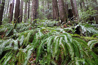
Random snippet of a saturated forest

At least it was raining when we started walking. You'd think we were hiking in Oregon or something. It never really rained hard during our visit to Kentucky Creek but hours of hiking in a continual downpour soon rendered us as sodden and soaked as the forest we were hiking though. Puddles lay on the trail and encroaching ferns were only too happy to transfer water from frond to clothing. Suffice to say, our raingear was put to the test today. 

A veritable carpet of false lily-of-the-valley

The noisy rat-a-tat-tat on hat brims from the steady rainfall would be a constant throughout the hike. However, no complaining allowed because rain makes the forest green and we do enjoy hiking below tall trees with a healthy understory of ferns, salal, and other assorted vegetation growing underneath. Moss claimed all that did not move and cliffs, boulders, and fallen trees alike were covered by a soft mossy blanket. Green was the watchword here as we hiked in a verdant forest beneath a brooding sky.

Kentucky Creek was always heard and/or seen

Once raindrops roll off trees, branches, leaves, and hikers, they eventually find their way into Kentucky Creek. Rain makes creeks flow and a very wet spring had Kentucky Creek coursing along in rather vigorous fashion. The stream tumbled through its creek bed of mossy rocks, the whitewater seemingly luminous amongst the dark trees under the dark clouds on a dark day. Several small unnamed waterfalls dropped over several equally unnamed ledges in what was a prelude to the Kentucky Falls main event.

Translucence in a trillium flower

Rain renders trilliums soggy, too. Like some people, trillium flowers tend to show their age by changing color from pale white to dark maroon as they get older. The current rainstorm pelted tired pink trillium flowers with an incessant deluge and the semi-transparent petals became quite saturated with water, folding over on themselves like wet crepe paper lying in a spilled drink on the dance floor.

My favorite fungus-bearing footbridge

About halfway down to the upper falls, the trail crossed Kentucky Creek on a rustic footbridge that seemed to be more moss than wood. On the bridge, bird's nest fungus grew in prolific bunches on the rails and posts of the span. Normally, I find this particular fungus on the ground and am always grateful to see them flourishing on this bridge, for I don't have to lie down on the ground like normal to get a photograph, especially on a wet day when the ground is muddy,

Upper Kentucky Falls

A roar sounding like the world's largest fire hose advertised the presence of Upper Kentucky Falls. The trail made several switchbacks from above the falls down to the cascade's splash basin, each switchback providing an opportune vista point from which to admire the photogenic cascade. Just like me, the falls were impressive and noisy, and that only stood to figure because the creek was so full of water. The mist emanating from the waterfall blew into our faces but from our standpoint, it was just more water in the air and no different from our hiking experience up to this point.

North Fork Smith River Falls (left)
and Lower Kentucky Falls (right)

Another mile or so of hiking down the forested creek canyon delivered us to Lower Kentucky Falls where it was more of the same but twice the fun. Here, Kentucky Creek plunges over a ledge to create Lower Kentucky Falls. Approximately 25 yards to the left, the North Fork Smith River does the same so you have two large waterfalls thundering next to each other for all of perpetuity. It's not often you get to see two waternal-twin waterfalls tumbling side-by-side in such close proximity to each other.

A fern asks for a peanut

We tarried at the lower falls for a bit to admire the view but mostly to postpone the hike up and out of the canyon for as long as possible. It had been all downhill to this point and we'd regrettably "enjoy" the uphill yang to the downhill yin on the return leg. Good thing I brought the uphill legs! I actually felt walky and pretty much power-hiked my way up the canyon in the rain.

Bird's nest fungi on a footbridge post

I was trying out a new raincoat and it was waterproof for most of the hike. However, by the time I reached the trailhead, the coat had given up the fight and I was soaked thanks to the fabric's acquiescence to the elements. The temperature was pretty chill too, and I gratefully partook of the car heater while I waited for my comrades to straggle back to the trailhead. Good things come to those that wait, they say, and there I go again, giving credence to what "they" say.

Smith's fairybells were seen on occasion

For more photos of this hike, please visit the Flickr album.

Saturday, March 27, 2021

Kentucky Falls


It's not funny if you have to explain the punchline. As we were lacing up our boots at the Kentucky Falls Trailhead, I offered up the factoids that Kentucky Creek was flanked on either side by Roman Nose Mountain and Mount Popocatépetl, adding that the three place names were a geographic tribute to primitive cultures and incomprehensible dialects. What I got back, instead of wry chuckles, were perplexed looks and several earnest and sincere "Wow, really?" questions. My hiking companions got it when I, my voice laden and dripping with sarcasm, answered a question with a question "Have you ever spoken to anybody from Kentucky?" I may have lost my entire Kentuckian readership with that one but hey, it's probably only one guy anyway.

All life should be like a walk in the forest

Even though Kentucky Falls was the main reason for our outing, this hike was mostly all about the forest. The morning sunlight was slanting through a cathedral-like grove of tall trees arching overhead like so many ribs in a Gothic basilica. You couldn't help but tilt your head heavenward like an awestruck pilgrim entering Notre Dame (or any other cathedral of the era) for the first time. The green glow from the trees, ferns, and moss was pervasive and small thumb-sized birds made fist-sized twitterings as they scolded hikers celebrating a decidedly green spring day. Below all the tall trees and twittering mini-birds, tri-petaled trillium flowers added their own special grace and elegance to the reverential scene.

A small but boisterous piece of Kentucky Creek

We were hiking nearly at the bottom of a canyon carved over the epochs by Kentucky Creek. When not in a truly sublime forest, we found ourselves hiking on a trail etched onto exposed cliff faces, all colored green by the ever ubiquitous moss. Initially, the stream pleasantly coursed through the trees before picking up speed. In a practice run for the big leap at Upper Kentucky Falls, the creek jumped off several ten-foot ledges, each a worthy cascade in its own right. And speaking of big leaps, I didn't do any. Eventually, Upper Kentucky Falls hove into view as the path switchbacked down to the waterfall's splash basin.

In all its Kentuckian glory

Roughly about 100 feet tall, Upper Kentucky Falls was carrying a large volume of water, seeing how Kentucky Creek was swollen with spring runoff. The sound of the falls echoed throughout and we all stopped to contemplatively admire the picturesque cascade roaring in the shady canyon. Here on the west side of the distant Cascades Mountain Range, waterfalls are about as rare as a mosquito in late July, which is to say they are not rare at all. But even so, Kentucky Falls is arguably one of the better ones.

Moss rules this forest

After the requisite Upper Kentucky Falls view-soak and photo-op combo, it was more of the same as the trail continued to descend down toward the confluence of Kentucky Creek and the North Fork Smith River, our intended turnaround point. The forest was still eminently sublime, the morning light remained poetic, and the trail was flanked with elegant and graceful pale white trillium flowers to go along with yellow woodland violets, and white-to-pinkish oaks toothwort blooms. All of the floral colorations were but mere specks against a green backdrop of either moss, ferns, or salal.

Bird's nest fungi, en masse

Roughly halfway between the upper and lower falls, the trail crossed over a small creek via a rustic wooden bridge covered with bird's nest fungus. Generally seen on the ground or on decaying twigs, these tiny fungi are actually shaped like a bird's nest, sometimes containing small brown "eggs" which actually are spore capsules. 
Because of their small size, these fungus are not readily spotted when we hike by them, but the bridge here was absolutely covered with the diminutive fungi and much macro-lens photography ensued.

A beetle takes a pollen bath

About a mile below the upper falls, Kentucky Creek drops off another rocky ledge at Lower Kentucky Falls, made further notable that the lower falls and North Fork Smith River Falls tumble side-by-side over the same ledge. The scene is epic and I had every intention of hiking down there until a large chest-high log blocked the way with no means of bushwhacking around it, seeing as how it was sited on a steep near-vertical slope, and at right angles to the trail. The idea of swinging my leg and fresh hernia surgery incisions over that daunting obstacle made my "little boys" crawl back up into my abdomen in cold dread, so uncharacteristically I did the right thing and called my hike over at that point, darn hernia anyway.

Rustic footbridge over a small creek

This would be the last hike under the stultifying restrictions of the surgeon's dictates. After today, me and the boys are free to hike as we see fit, although I've been warned to listen to my body which doesn't really work, because so much of hiking is ignoring what your body tells you anyway. So, while my legs felt a little unfulfilled, I still wound up following the doctor's orders without really meaning to, thanks to a wayward log. 


For more photos of this hike, please visit the Flickr album.


Saturday, November 4, 2017

Kentucky Falls - North Fork Smith River

It had been a while since I'd been to Kentucky Falls. The hike down to the falls and back is a shortish 4 miles round trip venture and considering the long drive to the trailhead, it just doesn't seem worth the trouble for a mileage-addicted hiker like your merry blogster. However, Kentucky Falls becomes a worthy destination if you continue beyond the falls on the North Fork Smith Trail for a more reasonable 9 mile hike. But that's a shuttle hike venture, so a friend with another car is a minimum requirement, and I don't have any friends. Plus, two winters ago, floods washed out bridges and trail alike and it was nearly a year before the Forest Service was able to restore the trail from the effects of the rampaging river. For all of the preceding reasons, it had indeed been a long time since I'd hiked in the North Fork Smith River area.

Knobby and mossy maple tree
Good news comes in threes and the Forest Service had re-opened the trail earlier this year; the hiking club had a Kentucky Falls hike scheduled; and there were enough people with cars to ferry hikers back and forth from (and to) this end-to-end hike. The bad news was that the weather was somewhat damp and because the trail had not been usable for over a year, the trail was a little bit on the rough side. But hey, that's how the Friends of the Umpqua roll, we like our hikes wet and rough as a cat's tongue (without that dead tuna smell).

Small creeks ran across the trail
Actually, any complaints about the weather should be pretty mild. It had been raining heavily for a solid week and another storm was on the way. But as it turned out, the day of the hike lay between the two storms and was expected to be relatively dry. When the hike started, there actually was blue sky overhead but that didn't last very long. At least the rain didn't show up until we had hiked 5 out of 9 miles.

Follow the Yellow-Leaf Road!
It was obvious, once we started dropping down into the Kentucky Creek canyon, that autumn leaves would be a major portion of the hike narrative. Bigleaf maples had divested their leaves, so to speak, and the trail was covered by a thick mat of leafy duff. The sound of boots scuffing through rustling leaves was a constant all day long and there'd be no sneaking up on deer today, not that we'd ever want to do such a thing. But, on the plus side, there'd be no deer sneaking up on us, either!

Upper Kentucky Falls


A short walk down a leaf-covered path brought us to Upper Kentucky Falls. The waterfall basin was misted over, partly from encroaching cloud cover and partly from the waterfall itself. The recent rains made for high water volume and a loud roar from the falls. After a few minutes of oohing and aahing, we continued onward, crossing Kentucky Creek on a moist and leafy bridge. Everything was moist and leaf-covered on this hike.

Lower Kentucky Falls
The trail continued to lose elevation as it switchbacked further down into the canyon. At a little over the 2-mile mark, Lower Kentucky Falls came into view and we took a rough path down to a rickety wooden viewpoint below the falls. This particular spot serves up one of the most amazing sights in Oregon. Lower Kentucky Falls tumbles over a rocky ledge and about 20 yards to the left, North Fork Falls does likewise. How often do you get to see two large waterfalls do their thing side-by-side like that? I was so happy taking photographs of Lower Kentucky Falls that I soon found myself all alone on the wooden viewing platform, as all my friends had left. I hurriedly headed up the trail to rejoin everyone but It was about a mile later that I realized I had taken nary a photograph of the two cascades in their eternal and fraternal free-fall. Oops. I nearly wanted to turn back and execute a photographic do-over.

The North Fork flows through the dead leaves
Kentucky Creek came to an end shortly after the falls, as it ran into the larger North Fork Smith River. Likewise, the Kentucky Falls Trail came to an end as it ran into the longer North Fork Smith Trail. Initially, the new trail ambled relatively close to the North Fork but that all ended when the path made an abrupt left turn and charged uphill as madly as a bull in Pamplona.

Moss covers all that does not move
I had mentioned earlier this trail had been closed, and clearly it hadn't been maintained in the interim. Ferns, logs, and all kinds of other vegetation had encroached the path, which was barely visible at times. Good thing all those leaves had fallen, it kind of gave us a Yellow-Leaf Road to follow. In a forest of moss-covered trees, the route sort of leveled out high above the heard-but-not-seen river. The path was narrow and clung precariously to a steep slope and it was not unusual to step in a hole, or off the trail, or accidentally roll rocks down the hillside. With the tread being so covered by leaves, you really could not tell what you were stepping on and there was more than one pratfall by more than one hiker, your merry blogster thankfully excluded.

Valerie and David execute a creek step-over


Many small creeks were running down the hillsides and across the trail as we contoured the heavily wooded slopes of Baldy Mountain. Looking at the map, Kentucky Creek lies halfway between Roman Nose Mountain and Mount Popocatepetl, in a curious geographical dedication to three primitive cultures with forgotten dialects. Baldy Mountain is more of a geographical taunt to the hair-challenged, though.

Rheo shows us how to reach the hiker's bridge
Approximately 3.5 miles from the end point, we ran into obvious flood damage. Clearly, the river had appropriated the trail bed and now there were small braids of river current flowing where the trail should have been. Here, the trail crosses the North Fork on one of the more impressive hiker bridges ever to span a river. However, we had to ford several small branches of the river in order to get to the bridge and the formerly-stout span was now sagging in the middle. Upstream, there was a brand new bridge but not yet a trail leading to and from the bridge, it looks like the Forest Service is going to abandon or tear down the old bridge. All those years of faithful service, and the poor bridge doesn't even get to see out its remaining days getting pampered in an assisted-living facility.

One of dozens of leaf-covered footbridges on this trail
It was just after we crossed the bridge that I said "Hey. it hasn't even rained today!" Yes, I really did say that and yes, I really should know better. You all know what happened next: the clouds began dumping water on us in response to my impertinence. Oh well, there's not much to do about it except keep on walking. Complaining helps, too! Anyway, the final three to four miles were rather on the wet side as the trail ambled up and down through the woods along the river. Despite the rain, though, it had been a nice reacquaintance with this green trail in Oregon's Coast Range.

The North Fork, as the rain fell and the day darkened
For more pictures, please visit the Flickr album.