Saturday, December 9, 2017

Eel Lake

Eel Lake isn't very eely, that I can tell. I did do some cursory research into the small mystery as to how the lake came by its name but while bass, trout, crappie, steelhead, and Coho salmon inhabit the lake, there was nary a mention of a historical eel encounter, story, tale, or legend. After walking on the Eel Lake Trail, my theory is that from above, the lake has lots of arms that wriggle out from the main body like so many eels. I'm open to other theories, by the way.

Eel Lake, in all its eely glory
The lake is part and parcel of William Tugman State Park, with the western shore being the only civilized portion of the lake, what with campgrounds, park, boat ramps, docks, and kiddie swimming areas. The lake is not all that big but with all those eely arms, it would be a 40 to 50 mile hike if one were to hike the entire shoreline. However, that would be a venture with a high degree of difficulty as the Eel Lake Trail only follows the shore for about 4'ish miles; the remaining 35 to 45 miles would be by bushwhack through the densely forested slopes surrounding the lake. 

If Richard were a mushroom
When I started hiking, it was a crisp winter morning where the sun was out in full sunshiny glory that did no good at all, seeing as how it was 27 degrees. Naturally, the swimming area was devoid of any aquatic-inclined humans. The trail immediately crossed over Eel Creek and ducked into a well shaded forest that quickly had me rummaging through my daypack, searching for a few more layers of clothing. That was the only thing that was quick about this hike.

Orange eels emerge from the depths of the black earth
The mushrooms were out in full force on this chilly morn and I spent a lot of time lying on the ground, in search of the perfect photo of the perfect fungus. Not much hiking got done while engaged in this particular activity. Anyway, after photographically cataloging every fungal specimen sprouting from the ample decaying biomass flanking Eel Lake, I was grateful to continue hiking and warm myself up a little. By the way, there was a clump of orange eely fungi emerging from the earthen depths, maybe that's how Eel Lake got its name.

Alder grove
The trail spent about 90% of its time in the well shaded woods but on occasion, brief glimpses of the lake were seen through a frame of cedar and rhododendron branches. About 2 miles in, the cedar and conifer gave way to leafless alder, their bony arms stretching to the heavens in supplication. You could almost hear their anguished cry "Hey, give us our leaves back! We're freezing down here!"


Ankle-breaker bridge
And now a word about the "bridges" and "boardwalks": Numerous creeks crossed the trail and the path also ran through some swampy patches; both of these situations required some kind of human invention to ensure hikers remained dry-footed. The fine folks at William Tugman Park have fashioned crude bridges and boardwalks by laying poles across the various wet spots, with the poles oriented parallel to the trail. The cracks between the poles were then chinked up with mud. Those things were slippery and there was a high likelihood of a an ankle slipping between two such poles if one was not careful. I safely negotiated the obstacle course by keeping with my feet perpindicular to the poles, but sheesh!

Eel Lake, from the trail
The shoreline was quite serrate and the route spent a lot of time weaving around small coves and bays, ducking in and out like a boxer looking to land a punch. Eventually the path rounded an arm of the lake and began heading north, there was much rejoicing at the sunlight slanting through the trees next to the lake. The temperature became relatively balmy and all those additional layers of clothing were soon stowed back in the pack. There were several viewpoints along the way with benches strategically sited for some lakeside contemplation and I partook thererof.  

Fungi was everywhere
The length of the trail is officially advertised as a 3'ish mile long trail. But really, it sort of depends on the mood and ambition of the trail maintainers. Prior to this hike, I had perused a couple of hiking blogs and the consensus was that the trail disappeared into the brush long before 3 miles. However, I shall sing the praises of the trail crews for at the 3-mile mark, I was still hiking on a well-maintained trail. At the 3.7 mile mark though, the trail was following an eely arm that soon became choked with brush and debris. It became downright swampy even, and the trail quickly degenerated into a muddy mire. My brand new boots were sinking into the goo with attendant sucking sounds as I extricated one foot while the other one sunk into the smelly black muck. Past the fetid swamp, the trail disappeared into the brush on a faint track that looked like it was used by deer more than hiker, and that was my cue to turn around and head back to the park.

A mushroom sprouts from a stump
On the return leg, the trail angled up a short but steep incline and I lowered my head and focused on the hard work of hiking uphill. Suddenly and without warning, a wolf entered the limited field of vision underneath my hat brim and I pretty much near voided my bowels. Turned out the "wolf" was a friendly German shepherd whose owner was laughing pretty hard at my discomfiture. He said I squ-eel-ed like a little girl but I also flopped and twitched like a landed eel. Maybe that's how Eel Lake got its name!

Eel Lake, at the end of the hike
For more pictures of this hike, please visit the Flickr album.


Sunday, December 3, 2017

Oregon Dunes

Because I basically did not hike for a couple of months this year, I had pretty much consigned myself to one of my lesser years, in terms of hiking mileage. But then I did the math. Looking at the calendar and considering the remaining days available for the wonderful little avocation of hiking, there was an opportunity to just barely make it over a respectable 400 miles for the year. So, with Luna in mindless happy tail-wagging attendance, back to the coast I went for a moderate hike in the Oregon Dunes: no resting allowed for the mileage addicted.

Kind of reminds me of the time I put too
much detergent in the washing machine
The wise sages at NOAA had foretold a chance of rain and predictably, dark clouds hovered over the dunes when we started hiking on a paved trail tunneling through the ample vegetation. I've hiked at the Oregon Dunes quite a bit and am very familiar with the loop trail north of Tahkenitch Creek, However, as we descended through the coastal forest, I noticed for the first time, a small lake below and well to the left, kind of surreptitiously tucked away in a low spot surrounded by coastal scrub. For the sake of doing something different, dog and human abandoned the sandy track through the dunes and headed cross-country to the diminutive lake.

Off and running


It may have been just a small lake but it was a small lake I'd never been to before, never mind it looked like all the other small lakes peppering the dunes. We walked around the edge a bit before returning to the trail proper. Well, to be precise, I wandered around the edge while Luna eagerly jumped in, fervently swimming figure-eights in the black water.

Happy place on Earth, for both of us
Clearly, Luna was in her element, be it either open sand or marshy water. She was streaking all over the place, ears laid back by the breeze as she sprinted madly in random circles and curlicues with no particular purpose that I could fathom. When we entered the deflation plain forest behind the beach foredunes, she found the puddly trail in the thick forest to be another of her happy places. Come to think of it, everywhere except the vet's examining room is a happy place for Luna.

Might as well initiate my new
boots into a Richard Hike experience
Between the beach foredunes and the deflation plain forest, lie a series of ponds and marshes. As the forest continues to entrench itself behind the foredunes, it encroaches into the marshes or vise versa. What all this translates to, hiking-wise, is a series of long and deep puddles where there normally would be a trail. Naturally, my boots were soon filled with water and a dog was mindlessly running up and down the trail, splashing through each puddle with unbridled canine mania. Wow, it was not at all like hiking with Dollie.

Sadly and truly, this is the trail
All good things come to an end, though, and eventually the trail spit us out of the forest and into the marshes where more wading was required. Was this an awesome hike or what? Although the question was intended to be rhetorical, Luna's answer is in the affirmative.


The beach was littered with dead pyrosomes
The next several miles were on lonely beach, with just Luna, seagulls, sanderlings, and my own idle thoughts for company. One oddity on the beach were some clear plastic tubes a couple of inches long, the whole beach was littered with the stuff. Curious, I picked one up and realized it wasn't plastic but was some sort of animal carcass. I was guessing sea cucumber but further post-hike research revealed the mysterious creature to be many creatures instead; these were pyrosome colonies. Apparently, they tend to inhabit tropical waters and don't visit Oregon much; solving the riddle of their sudden and unexplained appearance in the Pacific Northwest is what's keeping marine biologists from sleeping at night these days.

The stormy clouds were spectacular
To the south, an incoming storm cast the sky with a dark and moody glower. The view to the north was not as dark but mist made it hard to see any distance. It seemed like  the light, clouds, and shadows changed with every step I took, and I now have hundreds of surf and beach photos to prove it. Periodically, sun beams would break through the cloud cover, illuminating some lucky portion of the ocean surf.

Sanderlings, before Luna chased them
Seeing how there were so few distractions for an attention-deficit dog, I slipped the leash off of Luna and let her run free. My mistake. There were small flocks of sanderlings foraging in the wet sand and Luna made it her personal mission to make sure I hiked on a completely bird-free beach. Sanderlings prefer to run instead of fly, so when chased by Luna, they flew only a short distance away. Since Luna could still see them, the chase was resumed, and the birds flew another short distance away. Since Luna could still see them...you get the idea. Luna chased and chased until she was a small black dot on the horizon. Just about the point I was considering driving the car to Reedsport to meet her there, she turned around and ran back to me. Safe to say, she remained on the leash for the duration of the hike.

Tahkenitch Dunes, snaking through the dunes


We walked past the trail entering the dunes, eschewing for now a beach egress for a few more miles of beach walking. There was no logical turnaround point so I picked out a log on the beach in the distance and we walked to it before turning around and exiting the beach. The trail leaving the beach was mostly through grassy dunes next to Tahkenitch Creek. We enjoyed a nice overlook of an oxbow bend in the creek before we entered the world of sand.

Oregon dune, in the Oregon Dunes


Periodically, Luna was set free to splash and frolic in the numerous ponds dotting the dunes. The clouds seemed like they were dissipating and we enjoyed blue sky for a bit. I say "for a bit" because the dark clouds scudded in before we reached the trailhead. But hey, it didn't rain, I'm 7 miles closer to 400 miles for the year, and I didn't have to drive to Reedsport to pick up Luna. All that makes for another successful hike, in my book.

Gloomy, yet incredibly scenic...just like me!
For more pictures of this hike, please visit the Flickr album.


Friday, December 1, 2017

Bandon Beach


Every year, around this time, rainy weather comes to southern Oregon, ready to hang out for the next 19 months, or at least it feels like 19 months. In the higher elevations and mountains, the rain translates to snow, making it time to search for lower elevation hikes with snow-free trails. Well, you can't get any lower than the beach, so consequently my winter itinerary is heavily weighted towards coastal hikes.


Foam, foam, foam on the range....
Because I've spent a lot of miles on beaches in less than optimal weather, I've entertained many an opportunity to execute a life-saving sprint across the sands with a sneaker wave lapping at my heels. And, after being truly invested in the outcome of the wave vs. human contest, I've learned that prudence dictates a) knowing what the weather forecast foretells, and b) consulting a tide table and generally avoiding high tides.

Postcard moment on the beach
High tide at Bandon Beach was at noon, give or take a few minutes. Accordingly, Luna and I lollygagged at home before heading out to Bandon later than normal, timing the drive for arrival pretty much at the crest of high tide. When we showed up at the Coquille River jetty, waves were marching up the river channel in intimidating fashion and no boats were trying to exit Bandon Harbor. The beach between the jetty and the rocky islands of Coquille Point was awash with waves rolling up into the driftwood below the dunes. But it was a receding tide and would only get better so we set out, braving the mild inconvenience of having to hike in driftwood and run from waves. For some reason, there were no other beachgoers out and about, we had the entire beach strand to ourselves.

High surf pummels an island
Because the tide was still high, walking around the front of Coquille Point wasn't going to happen, so we scrambled over some rocks at the neck of the point. Our reward was the fantastic scenery waiting for us on the other side. Bandon Beach proper curved away from us, culminating in Gravel Point. The bay was filled with roiling white surf peppered with rocky islands and sea stacks. Driftwood covered most of the inland part of the beach, and the clouds were spectacular, allowing just enough sun to leak through, causing the sea to shimmer with a silvery light. Of course, all Luna saw was her people walking their humans, too; she whimpered wistfully, longing to socialize with her kind.

It was a marvelously gloomy view to the south
The pace of our hike slowed noticeably here, as much photography abounded. So many pointy rocks to take pictures of, each affixed with a lordly seagull on top. The tide was noticeably receding by now, so we had enough beach to walk comfortably on. I wasn't sure of it had receded enough to let us walk past Gravel Point but no worries, there was just enough sand to get by with some judicious timing of the waves. Luna was in her element as we sprinted around the point before the next wave came in. She is just a little bit faster than me. More graceful, too.

Rock islands and a silver sea
As we continued to hike along the beach, civilization gradually receded behind us. Accordingly, Luna was set free and she sprinted all over the beach. There were seagulls to chase, creeks to splash in, and an entire ocean readily available for a frolic and caper. We should all hike like Luna. Me, I mostly took photographs of the spectacular cloud bank straight ahead to the south.

A cloud floats above the beach


In back of us, the sky was blue but straight ahead, it was all doom and gloom. The clouds were dark and foreboding, portentous even. Tendrils of black rain hung from underneath and the sun poked holes in the dark tapestry here and there. A storm was in the forecast but apparently it was sweeping in a northeastern direction and pretty much left us alone.


Luna, in her element


Haystack Rock was the last island big enough to have a name and we continued on past until there were no more rocks or islands at all. Just miles and miles of soft sand stretching all the way to Port Orford, if one was inclined to walk 27 more miles in soft sand. Crooked Creek made for a logical turnaround point, although we had to allow for some quality dog-splash time in the creek.

A sneaker wave comes in to make me run
On the way back, it was nothing but blue sky ahead, apparently we were hiking underneath the intersection of blue sky and black clouds. The tide had retreated, leaving us acres of wet sand to hike on while fluffy sea foam marched across the wet strand, propelled by a coastal breeze. A small wave rolled in, catching the light just perfectly, and I stopped to capture the scene. Click, click, the camera was doing its thing when I realized the wave was not going to stop for a while. Darn sneaker wave, even though it was low tide! Normally, you sort of casually jog from the larger waves but not this one, I was running at a full dead-on sprint with the wave literally splashing at my heels. The sprint lasted nearly 100 yards and let's just say that I'm no threat to Usain Bolt as I lumbered across the wet sand like an obsolete Imperial Walker from the very first Star Wars movie. Luna thought it was great fun though, leaping and snapping at her leash, deliriously happy to be running with her lord and master while being totally unclear on the concept of running to safety. For the remainder of the hike, we kept a more respectful distance from the surf.

Looks irritated with my photo-taking
The remainder of the hike was more uneventful as the weather improved over the miles. Good thing too, I'm not sure how many more such sprints I had left in the tank. There was now a healthy population of fair-weather beachgoers out and about, including a group that creates artistic labyrinths on the the sandy beach canvas. They invited us to play in the nascent maze but we still had several miles to go. By the time we reached the Coquille River, the setting sun imparted a soft golden glow to everything. It was a perfect end to a great day on the Oregon coast.

Perfect ending
For more photographs of this hike, please visit the Flickr album.


Friday, November 24, 2017

North Umpqua Trail - Swiftwater Segment

I'm going to give one of my favorite hiking and backpacking equipment stores a plug here. REI has it right as far as I'm concerned. You can always rely on knowledgeable staff and a liberal return policy that really gives you the opportunity to thoroughly field test gear before deciding to keep it. But where they really have it right is on Black Friday, that insane shopping frenzy that takes place the day after Thanksgiving. On that day, REI closes its doors and admonishes its would-be customers "Get outdoors, instead". 

Mushrooms, on a decaying log
Our little Black Friday expedition ran the gamut of all possible Black Friday outlooks on life. Luna and I needed no particular color or day of the week as an excuse to get out on the trail, we are always all in. Son Carl was 50/50 on the matter but was up for a short hike. Liam, however, was 90/10 in favor of hitting the stores on Black Friday. His inner 10% made him happy to be out on the trail, but the remaining 90% reminded him that every step carried him further and further away from a good deal on a pair of socks. The poor boy was sorely conflicted about hiking on this hallowed holiday of sorts.

Mossy forest
Since the requirements handed to me were that the hike had to be reasonably short and close to home, we headed up the North Umpqua Highway. This summer, the North Umpqua area had been ravaged by forest fires and last I heard, much of the North Umpqua Trail was closed to hiking because of fire damage in the form of fallen trees and burned bridges. So, our plan was to hike from the first trailhead that was open for hiking. As it turned out, the first trailhead open for hiking was the first trailhead of the North Umpqua Trail, located at Swiftwater Park.

Deadline Falls was not very "fally"
The weather had been pretty crappy all week, but we picked a glorious day to go hiking. It was crisp and chilly, but sunlight and blue sky sort of greeted us as we set out on the North Umpqua Trail. It is a North Umpqua truism that no matter which side of the river you hike on, the other side will be bathed in sunlight while you shiver in the shady cold, and this day was no exception. Below the shady trail, the North Umpqua was running full of rain water and Deadline Falls was not a waterfall on this day, as it was overwhelmed by the swollen river.

Dead fireweed leaves rattled as we hiked by


However, due to the Cable Crossing Fire from several years ago, we eventually enjoyed the sunlight we were so rightfully entitled to. Because of the fire. the trees are all dead here and a healthy waist-high cover of fireweed, dried and desiccated from the winter die-off, rattled like the last gasp of an asthmatic skeleton as we hiked past. The ample fireweed patch indicated the dead trees had met their demise years ago instead of perishing in the raging fires of last summer.

A small piece of Fern Falls
Fern Falls showed up a couple of miles into the hike, and both Carl and Liam were impressed. The falls have lost their luster over the years a little bit, as fire debris in the form of black logs, branches, and other detritus have visually cluttered up the delicate little waterfall. But it was still an enjoyable stop as the fresh waterfall breeze cooled us off a bit, not that we particularly needed cooling off on this winter morn.

Gotcha, finally!
We continued on the up-and-down trail, listening to twittering birds, babbling brooks, and Liam loudly complaining about not being at the mall on Black Friday. At Deception Creek, a stout footbridge spanned the creek and we stopped for a moment to enjoy the scenery and the sunnery. A pileated woodpecker was working over a tree, high up the trunk. I've seen these birds a time or two but they are hard to get a picture of as they have a knack for circling around to the back side of the tree just as you set the f-stop, ISO, and aperture settings on the camera. However, this time I was able to get a decent photo of the red-crested woodworking bird and that alone, made this hike memorable.

Jumping for joy


We didn't really have a destination in mind, excepting Liam, who had fixated on the mall as a perfectly good destination in mind. So, at a little over 2.5 miles, we showed him some mercy and turned around. He was practically giddy with joy, and beat us back to the trailhead. Despite the relative puniness of the hike, a good time was had by all and we all agreed to make a more serious effort on any other day besides Black Friday.

A leafhopper, currently not hopping
For more pictures of this hike, please visit the Flickr album.


Sunday, November 19, 2017

Siltcoos Trails

This hike was destined to be short. The Siltcoos Trails aren't very long in the first place but I could have certainly added some more miles by hiking further along the beach. However, heavy rain was in the forecast and high winds were expected to arrive around 4 o'clock in the afternoon. Lucky Luna, though, she got to come along on this 4 mile exploration of the Siltcoos Recreation Area that was more photo shoot than hike. My arm can only take so much mindless leash pulling too, so there's one more reason for the shortness of the hike.

A bench with a view
There are three not-very-long trails in the Siltcoos River vicinity: Lagoon Trail, Chief Tsiltcoos Trail, and the Waxmyrtle Trail. All of them meet in the middle, so to speak, the middle in this case being the Stagecoach Trailhead. Item number one on the diminutive hiking itinerary was the Lagoon Trail, a pretty little loop path that showcases man's insensitivity to the environment.

The still waters of Siltcoos Lagoon
The Siltcoos River runs from nearby Siltcoos Lake to the ocean and it used to snake back and forth in a pronounced oxbow bend. I say "used to", because in the 1930's, the road leading to the campgrounds and beaches was laid right across the neck of the oxbow, effectively cutting it off from the river. So nowadays, the river runs straight, paralleling the road, while the tepid lagoon pools with standing rainwater. In yet another fine exhibit of our proclivity to mess with the environment, an invasive reed known as parrotfeather is taking over the swampy lagoon and over time, the lagoon will dry up and become a meadow, which will, in turn, eventually be swallowed up by the coastal forest.

Typical trail scene on the Tsiltcoos Trail
But for now, the lagoon is not without its attractions. A series of boardwalks ambled next to the black waters of the picturesque lagoon and I took a series of photographs of the glassy surface, before I let Luna frolic in the still water. Upon her frenzied entrance into the lagoon, the surface was glassy no more, The short loop followed the lagoon's edge and several benches allowed hikers to sit and contemplate a fetid swamp, if they so desired.

Translucence
Next up was the Chief Tsiltcoos Trail, which was basically a walk through a coastal forest. The trail did provide a brief uphill section, though, imparting a mild burn to lazy leg muscles. Much photography ensued, mostly of sunlight slanting through the trees, mushrooms sprouting everywhere, and all the ferns, moss, lichen, and salal you could ever want to point a camera lens at. Much berry grazing also ensued, as the coastal huckleberry bushes were amply adorned with juicy black berries.

Behold the mighty Siltcoos!
So, two loops down, one to go. Well, to be technical, the Waxmyrtle Trail is not a loop but an out-and-back venture, running from Stagecoach Trailhead to the beach south of the Siltcoos River. After crossing on a roadway bridge, Luna and I grabbed the dirt path on the opposite side of the river. The trail was right on the edge of the river and when I say "right on the edge", I mean right on the edge. If the river level was to rise a foot or so, then it certainly would be a wet hike to the beach, making a certain water-addicted dog very happy. If you are not sure which dog I am referring to, her initials are Luna.

The Siltcoos journey ends here
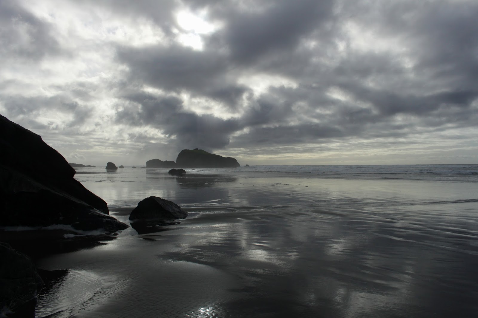
After a short walk, the path peeled away from the river and headed uphill on a mossy set of stairs. Now sticking to the bluffs above the river, the route continued to amble through a lush coastal forest. Periodic breaks in the vegetation provided openings from which to gape at the Siltcoos River below. If there weren't openings in the tree cover, not to worry, there were plenty of use trails leading to plenty of viewpoints. The river wandered through a grassy delta in several sweeping oxbow curves before becoming one with the now-visible ocean.

Clouds were blowing in
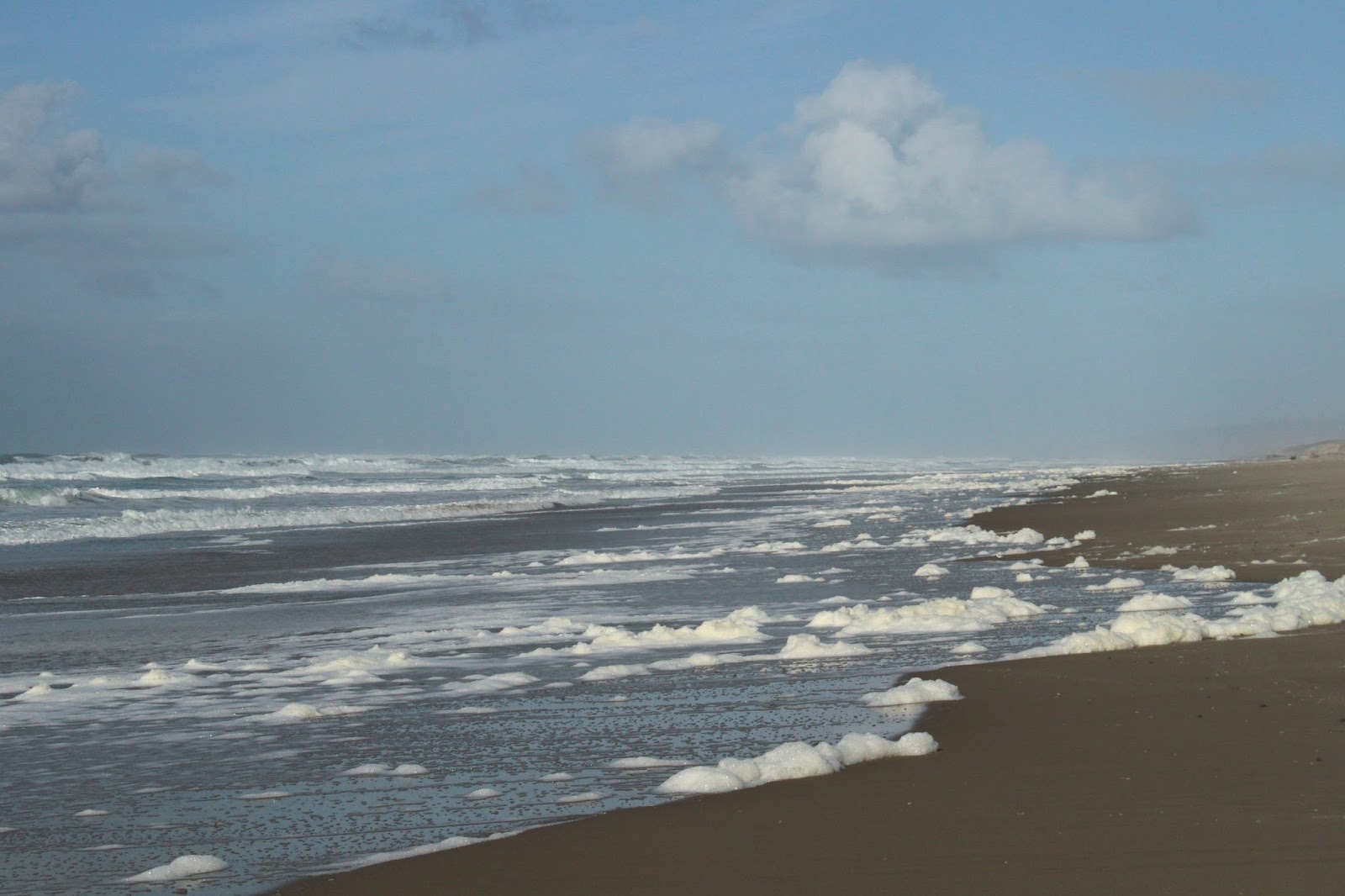
The trail quickly morphed from a forested trail to a sandy track running through the marshes behind the foredunes. More quality splashing time for Luna and more quality camera time for me. We each do enjoy hiking in our own different way. A quick and sandy up-and-over the foredunes brought us to the beach where Luna was demonstrably overjoyed to become unleashed. She probably ran 10 miles within two minutes as she splashed in the waves and scattered seagulls, all the activity accompanied by exuberant yips of doggie delirium.

Luna hikes into wind-driven grains of sand


Off shore, there were clouds hovering over the ocean but it seemed the forecasted storm had not yet arrived. However, the high wind advisory was warranted as the wind was blowing, by my guess, close to 40 miles per hour. I considered walking north on the beach but the idea of leaning into the wind and high velocity sand grains for a mile or so on the way back wasn't very appealing so the hike was done at this point.

Yum!
Fortunately, the high winds were just that: high winds, in that they were blowing high above in the treetops while leaving us ground-dwellers alone and unmolested. Well, unmolested unless I lay down to take a photo of a mushroom, then a dog licked my ear whenever that opportunity presented itself. On the drive home, a brisk rainstorm overtook us; it certainly was nice to avoid all that on this short hike on the Oregon coast.

My hiking companion
For more pictures of this hike, please visit the Flickr album.