Saturday, August 22, 2015

Bandon to Port Orford backpack

In a sense, this summer hike on the coast had a lot do with winter. Last January I was hiking in the Cone Peak area and there's no way a 5,600 foot peak should have been that accessible in the middle of winter, at least not without snowshoes and a whole bunch of warm winter wear. On that hike, the only snow visible for miles and miles were on the Three Sisters and Mount Jefferson, four white pimples surrounded by a vast tract of dark and snowless forest. I remember thinking "This is so not good", as surely the lack of snow was a harbinger of what surely would be a merciless fire season.

Feet got wet at China Creek
While I was correct in my presumption, we sort of skated here in southern Oregon, fire-wise. Yes, we did have wildfires but none were as catastrophic as they could have been. On the other hand, Washington, Idaho, and eastern Oregon caught the flaming brunt of a snowless winter as the fires there were huge and numerous. One of those fires, the Eagle Fire, caused us (Lane, Dale, and I) to scratch a 50'ish mile backpack in the Wallowa Mountains. We didn't want to backpack in the southern Cascades either, as the fires here were pretty much filling the air with particulate matter and turning the blue sky a dirty shade of gray-brown. It'd be like backpacking in Los Angeles, Tokyo, or Mexico City, the air was so dirty. By default, we headed to Bandon for a shorter, easier, and presumably more smoke-free hike.

All the sand you could ever want to walk on
The Oregon Coast Trail is on my list of things to do but one of the drawbacks to the OCT is that significant portions of the route are on roadways. However, the longest section of roadless hiking on the OCT is the 27 miles from Bandon to Port Orford. Highway 101 heads inland and the land between the highway and the ocean is mostly undeveloped. By hiking the beach from Bandon to Floras Lake, hikers can get a taste of what a truly wild beach can be like. Hikers can also get a taste of what 3 days of walking on soft sand can be like and that's not all that much of a good thing. It's both the best and worst of beach hiking.

This is going to be easy!
We started at mid-day because the restaurant where we ate breakfast was incredibly slow. Good thing we had the time! At any rate, we set out from the Inn at Face Rock (Thanks, Inn, for letting us park our car there) and sallied forth onto the beach, heading due south. The sand at Bandon Beach was firm and hard packed and we made rapid progress underneath a cloudless blue sky.  Hey, this was going to be an easy hike!

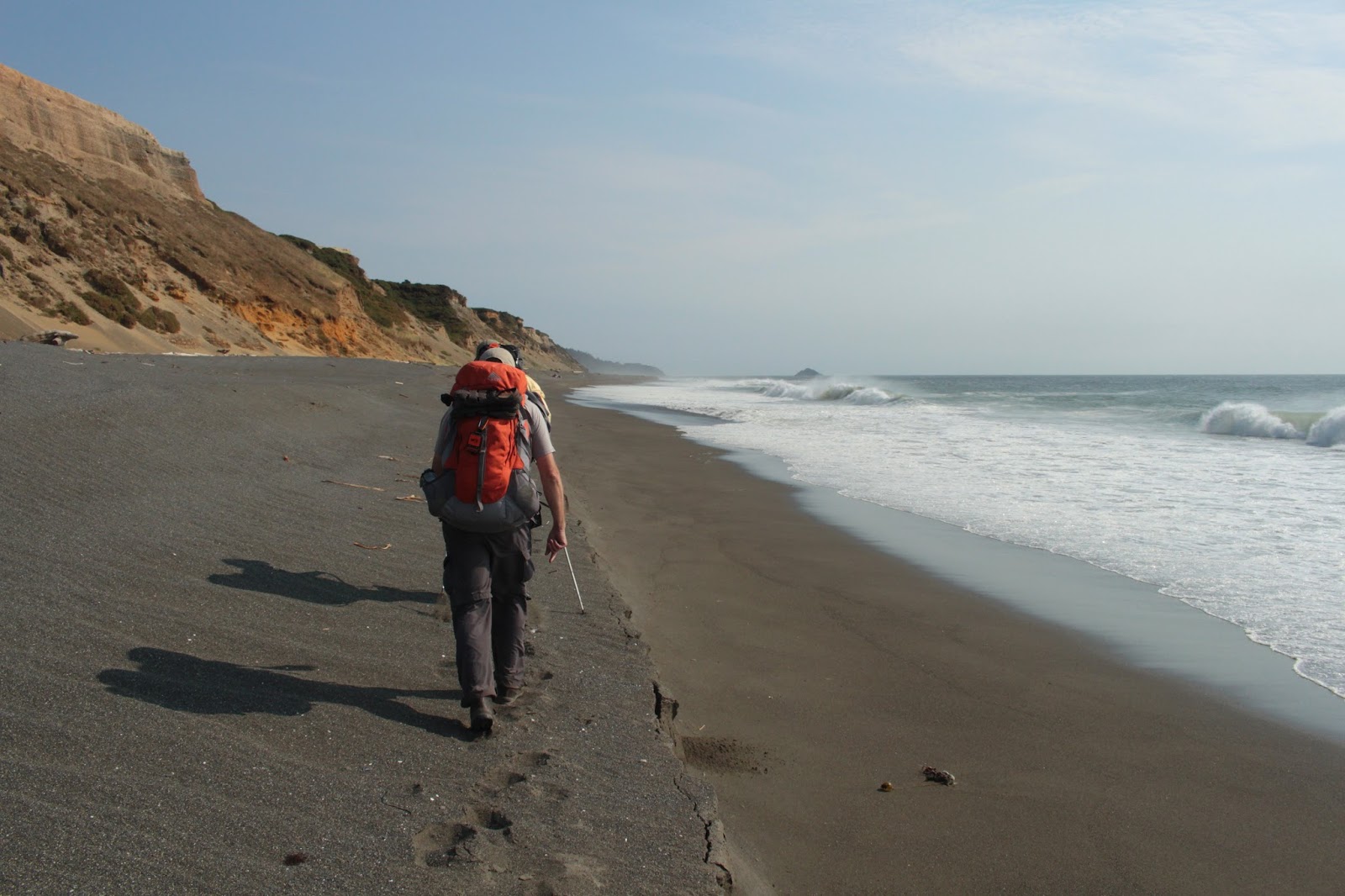
My view, for the next 20 miles
Things changed when we hit the mouth of the New River; well, where the mouth normally would be. In this dry summer, the mouth was closed shut by a formidable sand bar and the New petered out within sight of the Pacific Ocean. And just past the New River, the sand changed from hard to soft. Our legs immediately started screaming in agony from the soft sand walking.The best way I can describe it is that walking on soft sand uses the same muscle groups as that evil stair-stepper at the gym, and with the same result: burning quads and calves. The good news was that we would feel the burn for only the next 20 miles or so!


Once past photogenic Haystack Rock, it was nothing but empty beach for the rest of the day. Just us, gulls, and flocks of sanderlings running comically in front of the incoming waves. We were excited to find a few pristine and perfectly intact sand dollars but that soon lost luster as there were like millions of sand dollars strewn about, all in mint condition. 

A log gets slapped by the sea
We were walking through the snowy plover habitat and hikers are required to walk on wet sand only. Amazingly, about 10 miles of dry sand had been roped off all the way from the New River to the public park with the rather unwieldy name of New River Area of Critical Environmental Concern, a few miles north of Floras Lake.

Exhaustion at the New River (photo by Lane)
A sign post affixed to the top of the beach foredunes marked the location of the BLM "campground". The amenities were rather sparse, consisting of a few planks upon which to sit, acres of grass and sand and most importantly, official permission to pitch a tent. We didn't care about the lack of comfort as we were just happy to drop our packs and quit walking on soft sand. The New River was a short walk away and we replenished our water supply. The day had been sunny and naturally, we were treated to a superb sunset, our reward for all that hard work. Now that I think about it, we could have enjoyed the same sunset seated in a car parked at Face Rock but that's beside the point.

Dale, Lane, and Barbie


The second day dawned cold and foggy. While it wasn't raining, the air had that liquidity to it that left us all wet anyway. If anything, the sand had gotten softer than the day before. And just like the day before, the sand sloped steeply into the ocean while on the landward side, a large sand bank had been created by wave action. Trying to be good citizens and walk on the wet sand was exceedingly difficult as we occasionally had to run from large waves only to find ourselves trapped by the sand bank. Our feet got wet and we thought the ocean quite rude.

Yup, the sand is soft
Eventually, we cheated and walked atop the sandy cliff. We periodically found veins of hard sand and chased them like miners following a depleting vein of gold. From the first "hey, I found hard sand!" followed immediately by so-called friends cutting in front and chewing up the hardpack, we learned to keep our hard-sand discoveries to ourselves. However, we learned to watch our comrades' feet and if any of us was walking with a smile on his face, two others cut in front and took the smile away. So we learned to fake walking in soft sand even if the sand was pleasantly firm. We learned a lot about ourselves and our so-called friends as this sand walking turned out to be a pretty cutthroat endeavor.  

It's a tube thingy!
The beaches here are a beachcomber's delight and we found skinned baseballs, petrified wood, a boat, floats, and a rock that looked like the second coming of Elvis Presley (it's a miracle!). Lane was particularly excited when he found a metal tube that from his Navy days, he recognized as a container for sonobuoys. Me, I would have just called it a tube thingy, without Lane's vast reservoir of knowledge about obscure tube thingies. Thanks, Lane!  

We tried walking in the grass for a bit...didn't work!
A moment of levity occurred when, tired of sand walking, we decided to attempt hiking through the grasses behind the dunes. Through the fog, I could see a herd of elk walking in the pasturelands along the New River. But then Lane said they didn't really move like elk and on second glance, I agreed. Must be cows then but as they scrambled up and down the banks of the New River, they seemed way too agile for cattle. What were those things? As we pondered that question, totally mystified, the faint sound of sheep bleats carried through the mist. Well, it sure is easy to mistake sheep for cattle or elk!

Floras Lake
At Floras Lake, we stopped to replenish our water. I use purification tablets while Lane and Dale use water pumps. Naturally, I was done before they finished. I sat down in the sand and reclined against my pack and totally involuntarily, my eyes rolled up and I promptly dropped off to an accidental sleep. I woke up with a start, totally disoriented with no idea how long I'd slept or whether the guys had left me behind.  No worries, a pair of snores behind me gave it away; they too had checked out. Happy now, I re-closed my eyes and fell into another restful slumber. Afterwards, when we all woke up and resumed hiking, I told Dale and Lane that we had just slept together and I was warned that statement had better not appear in my newspaper story. But they didn't say anything about my blog!

A real trail is cause for celebration
Fully rested, we really enjoyed the hike from Floras Lake to Blacklock Point. We were hiking on the Oregon Coast Trail and best of all it was on a real trail with real trail tread underneath our very real feet. The path cut through a dense coastal forest and we grazed upon ripe huckleberries as we hiked. Several miles later we set up camp in the trees above Blacklock Point. 

Sunset at Blacklock Point
The cloud cover had taken away the sunset but amazingly, the sun dropped through a hole in the cloud cover and Lane and I enjoyed a quick photo shoot of the sunset. Unfortunately, a chill wind was blowing and after several minutes, Lane and I sought shelter in our respective tents. That night, some creature was in our campsite and was croaking "Raik,,,raik,,,raik,," in a strange helium-tinged cartoon voice; it was as if it was trying to talk to us. Maybe it was expressing appreciation of Cape Blanco's lighthouse beam sweeping through the trees every 30 seconds or so while the wind stirred the trees overhead.

On our way to the Sixes River


Day 3 started out misty but the fog burned off by mid-morning. My recollection of Day 3 was the day was bright and sunny but looking at my pictures later, the mist never really fully left. We set out on the scenic beach arcing towards Cape Blanco and as usual, we were soon grousing about hiking on soft sand. Desperate men do desperate things so about halfway down the beach, we beat through the beachgrass and found a cow trail that allowed us to walk on real ground and make quick pain-free progress to the Sixes River.

Lane fords the Sixes River
The Sixes was still flowing to the sea (this time of year, it's not uncommon to find the Sixes dammed by a sand bar) and it was a shallow wade across. None of us felt like walking on the beach to Cape Blanco so we grabbed the Oregon Coast Trail which climbed up the bluffs overlooking the bay. Astute readers will discern we were at this point, harboring an irrational animus towards soft sand. At any rate, the OCT wended its way through a shady coastal forest before delivering us to the parking lot next to the Cape Blanco Lighthouse. From there it was another short forest walk down to the beach on the south side of Cape Blanco.

Freaking hilarious!
Several miles later (on soft sand, too, darn it) we arrived at the Elk River, our intended campsite. The wind was really blowing but fortunately was at our backs. There were no trees at the mouth of the Elk and we'd have to pitch our tents on the sand in the wind, a rather dubious proposition at best. So, after a quick impromptu confab, we decided to hike the remaining three miles to our car. Dale and I crossed the Elk close to the ocean, where the river fanned out and made the crossing relatively shallow. Lane, on the other hand, crossed slightly inland and entertained Dale and I as he flailed his way through a waist deep river.

Please make the soft sand stop
The last three miles were in soft sand, but what else was new. I think I was getting into sand shape because while the going was slow and trudging, I had plenty of energy left when we reached the end of the hike. Afterwards, we stopped for dinner and the waitress told us the special was a turkey sandwich and we all flinched at the "sand" in "sandwich". I think we all have post-trail sand syndrome, or PTSD for short, but it sure beat walking in a forest fire.

This hike was golden
For more pictures of this trip, please visit the Flickr album.


Saturday, August 15, 2015

Dry Creek 8/2015

Take a dog to a creek and it's a splash fest replete with canine yips of joy and exuberance. Take children to a creek and peals of laughter ring through the trees as they frolic carefree in the stream. But take a hiking club to a creek and disgruntled mumbling and grumbling curdle the waters, or at least that's been my experience over the years.


"Mystery River"

Late July, I was on vacation in warm and sunny Ojai, California and I checked my email and found out I was leading the Friends of the Umpqua Hiking Club on a hike up "Mystery River". Turned out, all my bragging about hiking up Dry Creek was heeded and as a result, this hike wound up on the schedule. And here I thought no one ever listened to me. And much to my surprise, 11 daring hikers put on the water shoes and participated in this wet-footed venture.

Whee!
Of course, at the start everybody looked at me funny when I opened the trunk of my car and pulled out a 50 foot hank of rope. I guess I forgot to mention we had to rope down to the Sixes River to commence this hike: oops, my bad! Once we were all safely down and grouped at the river's edge, everybody had that "well, what next?" look,  so with a cheery "follow me" I waded into the river and started splashing downstream. 

"Poetry" in motion
I have hiked this hike with the South Coast Striders several times before and I must say, they have never exhibited the singular grace and athletic skills of the Friends of the Umpqua. Of course, I'm being sarcastic because grace is not really the word that would best describe our shaky progress down the river. To be fair, the rocks were covered in slippery algae and footing was tenuous and treacherous, I'd like to say I walked agilely like a water dog but I probably was flopping like a flounder, too.

I wonder why it's called Dry Creek?
Dry Creek flowed into the Sixes River on the opposite bank and the creek bed would be our route into the Grassy Knob Wilderness. Well, "flowed" is perhaps not the right word because Dry Creek was living up to its name, running drier than a Brit's wit. However, the dry creek bed made for a convenient, albeit rocky, roadway and we followed the creek upstream like a school of land salmon. The rocks were all caked in dried algae, indicating water had once flowed in this creek.


Now the fun starts

As we neared the bridge marking the wilderness boundary, big leaf maple trees began to make an appearance and small pools of water showed up in the shady parts. The two events are not coincidental as the maples replenish the creek by process of evaporation through their leaves. We ate lunch underneath the bridge, right next to a deep pool where we observed newts swimming languidly in the blue-green water.

Dry Creek slitherer
After lunch, we headed upstream into the wilderness proper. Magnificent old-growth maples hung over the tranquil creek. Newts were everywhere and we had to step carefully so as not to diminish the local population by a newt or two. Ahead of us, frogs leaped into the stream and hid on the bottom. The water was so pure and clear, the hiding was somewhat ineffective but since we were not frog predators, no frogs met an untimely demise as we hiked by. Garter snakes slithered along the shore and the peacefulness of the creek was broken up by high-pitched squeals of horror from some of the snake-phobic members of our group. 

Evidence of creek pixies
There was no particular destination to denote a turnaround point so everybody turned back when they had enough which meant the three passengers in my car were the group that hiked the farthest. At around the 4 mile mark, we turned around and headed back the way we came, enjoying the serenity of the creek until it dried up and returned us to the world of hot sun and rocks. This hike is one of my favorites and hopefully, there'll be a few more Dry Creek acolytes after this hike. I'm also glad to report there were no complaints about wet feet, either; my dog and grandchildren would be proud of the hiking club.

Slowly, the newts stalk their prey
For more pictures of this hike, please visit the Flickr album.


Saturday, August 8, 2015

Umpqua Spit 8/2015

The only other time I backpacked to the end of Umpqua Spit, the weather, the clouds, the sky, and (most of all) the sunset were truly spectacular. Based on that wonderful weekend, Umpqua Spit became a recent selection for a casual two-day backpack. Memory can be selective and I neatly overlooked my first hike there with friend-cum-victim Lisa. On that ill-fated venture we had to contend with truly horrendous weather and running for our lives from a sudden sneaker wave. But since the weather was so fantastic the next time out, I'm now a wild-eyed hand-waving Umpqua Spit zealot. Actually, I'm sufficiently wild-eyed and hand waving enough without the Umpqua Spit-inspired zealotry, but I digress. At any rate, I sang enough praises about the spit that Lane and Kevin both decided to join me for a fine spittin' weekend at the Spit.  

Who let the dogs out? Who? Who?
At first. the weather was reminiscent of my earlier (good) trip what with blue sky and puffy white clouds floating above the Oregon coast on a gorgeous day. Kevin brought along his dog Wish and Wish was only too happy to splash in the surf. For a while we were joined by a black dog who merrily frolicked with a kindred canine spirit before a distant call from his owner ended all that fun.


Tidal runoff
There wasn't a lot of water in Threemile Creek and boots barely got wet as we splashed across. It was low tide and the surf had retreated below some sand bars, trapping water behind the bars in large pools that a certain dog liked to splash around in. The pools drained in haphazard fashion and we had to wade across a fair number of runoffs. At the larger pools, we simply detoured around them.

There will be no birds on the beach, by canine edict
Gulls and flocks of sanderlings were parked on the sand and Wish made it his personal mission to make sure all the birds he could see were airborne and off what he deemed to be his own private beach. Us photographers had to take hurried pictures of the birds before the dog chased them away.


Where'd the sunny day go?
Roughly, it was about 6 miles to the jetty at the Umpqua River and the closer we drew to the jetty, the least amount of sun shone down upon us. A thick cloud cover was coming in and the temperature cooled down quite a bit. It was tending towards stormy when we arrived at the jetty and so much for the Umpqua Spit 'n shine.


Home, home on the spit
At the jetty, we left the beach and scrambled up to the top of a grassy dune and pitched our tents in the tall grass.  Lane was my immediate neighbor and Kevin was just beyond Lane's site. Even though Kevin was only about 25 yards away from me, his tent was completely invisible due to the tall grass on the dunes.


Rusted equipment on a rocky point
After setting up camp and eating dinner, we took a short hike up the river along the jetty . We explored a small and rocky point in the middle of Winchester Bay that looked like it had served some industrial purpose in the days of yore. There were rotting pilings and a corroded bin of some sort that contained rocks. The point was littered with rusty machine parts and equipment and one plastic toy shovel that probably did not originate from the days of yore. A nice view of the bay, the town of Winchester Bay, the Umpqua Lighthouse, and the sandy spit was appreciated by all of us, except for maybe Wish who just lived in the moment and didn't really care about all that stuff.

Morning, gray and wet
Unlike my first trip, there was no sunset as the heavy cloud cover took care of that. So we tucked in early as the fog rolled in. I had brought my two-man Kelty tent and it had been field tested in rain so I was pretty secure about keeping the wet air out. However, the field test had been several years ago as I was so reminded when a cold water drop plopped on my forehead. And that was my night: drip, drip, drip. I couldn't tell if it was condensation on the inside or fog leaking through the tent from the outside, my wet forehead could make no such distinction. Not the most comfortable night I've spent on a backpack trip!

Hiking into the void


Early in the morning, I crawled out of my soggy sleeping bag and entered a foggy world of gray, gray, and more gray. It was so thick, the ocean was not visible at all, although the sound of the waves could be heard. We struck camp quickly and began walking the six miles back to the car. It was foggy so we couldn't really see much although Wish still had no problem spotting birds to chase. After six perfunctory miles in the gray, we enjoyed a fine brunch at Don's Diner in Reedsport. Life is good when you have a full belly after a full weekend.

Umpqua Spit is Number 1!
For more pictures of this hike, please visit the Flickr album.


Saturday, August 1, 2015

South Slough


My buddy Lane had a computer problem recently and tragically, he forever lost a lot of his pictures. "Without the pictures, it's like it never happened. It just never happened at all" he moaned, wiping tears from his eyes. Well, halfway through this hike, I knew exactly what he meant when my camera suddenly quit working. So, using Lane's logic, we only made it halfway through a loop hike in the South Slough. Apparently, we are still there at the bottom of the loop, waiting pitifully for anyone to come give us a ride.

The Berry Hunter
I've driven past the South Slough National Estuarine Research Reserve entrance many times, whizzing by on on Seven Devils Road on the way to Cape Arago. However, I never felt the need to stop by for some hiking research of my own as I've always deemed the slough trail system too short and too tame for a Richard Hike. However, it was just right for a couple of young grandchildren so Aiden, Coral Rae, and I joined the Friends of the Umpqua Hiking Club for half of a short hike. The other half didn't happen, remember?

Old home on the Hinch homestead
This was a two-parter hike and the first portion was a short loop hike down to the former Hinch homestead with ruined home and barn adding a rustic flavor to this hike. And speaking of flavor, the blackberries and coastal huckleberries were in full fruity song and young Coral Rae walked slower and slower as she grazed the ample berrytude. Some older hikers were spotted doing likewise.


Whee!
After this short loop, we hopped in our cars and disembarked at the visitor's center where Coral Rae was disappointed her miserly grandfather wouldn't buy her a stuffed panda on demand. We began on the Ten-Minute Loop Trail and all I could think was "Ten-Minutes?  There's no ten minutes in hiking!" And just a couple of minutes later, we grabbed the North Creek Trail and were in business.


Arrival at the slough

The trail dropped down the creek's drainage, steadily losing elevation through some lush coastal forest. It was all thimbleberry, huckleberry (much to Coral Rae's delight), salal, ferns, and foxglove. The trail bottomed out onto the grassy marshes of the South Slough and it was there that technical difficulties began to rear their ugly electronic heads. I noticed my camera was having problem with the white balance and focusing. After some mild consternation, the camera began flashing an ominous message "Camera body is not communicating with the lens. Turn off the camera and clean the contacts on the camera lens". Just to hammer the dire point home, there also was a large red triangle with an exclamation point flashing on the display screen. 

One-hundred and twenty lens cleanings later, the camera could at least take one picture before giving up the whole picture taking thing. So the rest of the hike never happened but if it did, we took an old railway trail through grassy sloughs while bad cameras were hurled into the marsh in frustration. OK, that last part took place only in my imagination. Before beginning the big climb back to the visitors center, we paused on a wooden viewpoint that looked like a giant tree house.

Broken cameras make me sad and I want my binky
Both Aiden and Coral Rae were feeling walky, apparently, so I just tucked in behind them and followed them up. Whew! Those young legs can really scoot uphill!  However, they were burned out when we did finally reach the visitor center while I still had some gas in the tank, chalk one up to old-people pacing!

We had one more item of interest left to complete the day. A short drive to a pullout on Coos Head lead to a steep trail dropping through the trees on the cliffs of the head. Tree hugging was involved. But there was a tunnel cut through the head for some mysterious reason and we used the tunnel to cross over to the other side of Coos Head.


What happens to misbehaving cameras

And what was on the other side? Why a secret little cove of a beach. And in order to get down to the beach, one had to rappel down on a wet rope. My two young charges now thought this was the coolest hike ever and they scrambled up and down the rope like the little monkeys they are, Of course, there are no pictures so this really didn't happen. After we returned to the car, I backed the car over the camera and then went forward. Back, forward, back, forward, and so on until that miscreant camera had been properly punished. Of course, that didn't really happen, either.


Our crew
For more pictures of this half a hike, please visit the Flickr album.